
SACRAMENTO, Calif. — From drought to flood, it’s the vicious cycle of weather extremes in California.
It may be hard to imagine more than seven million Californians are at risk of flooding as we enter our fourth year of drought. In fact, in the past 20 years, every California county has received a flood-related emergency.
In the second part of our "megaflood" series, we’re looking at why our system of river levees, dams, and reservoirs put the Sacramento and San Joaquin Valleys at one of the top spots in the country for flood risk.
"We're already in a world where the likelihood of a catastrophic flood has doubled in any given year," said Brian Johnson with the Central Valley Flood Protection Board. "That's the kind of thing that keeps people like us up at night."
The mission of the Central Valley Flood Protection Board is to update the state’s plan to keep us all safe from catastrophic flooding.
"People talk about how we may be overdue for the 'big one' for an earthquake in Northern California," said Johnson. "That's probably true for the big flood as well."
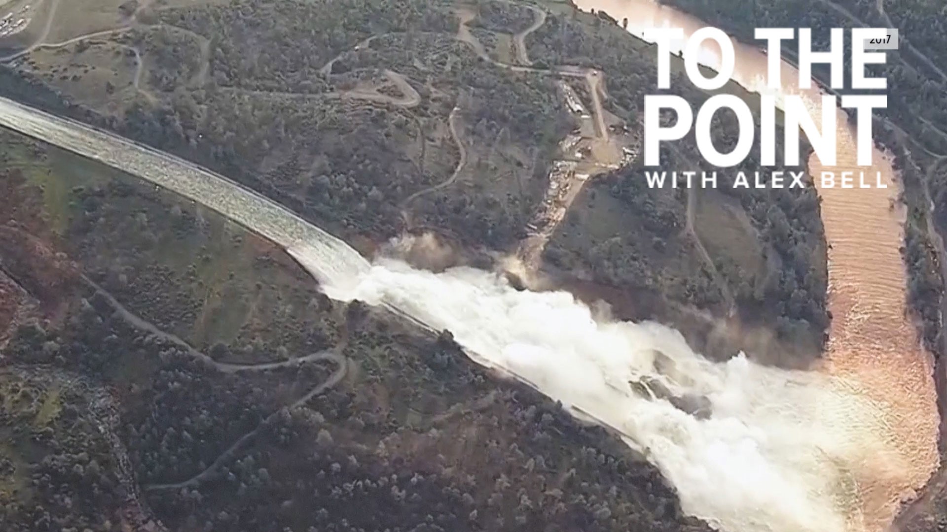
It would be a flood event dwarfing the record-breaking water year of 2017, when the Oroville Reservoir couldn’t hold the amount of water coming in from the rain and Sierra snowmelt.
"In February of that year, we had a series of storms coming into the lake. We were operating the lake like we normally do to hold back some of the water and then release it gradually into the Feather River when we found the damage in the spillway," said Ted Craddock with the California Department of Water Resources.
The damage made it nearly impossible to release enough water from the rapidly rising lake, putting pressure on the country’s tallest dam -- standing over 70 stories high -- and its spillways.
The risk of massive flooding grew by the hour for people living in the valley below.
"As a mom, the first thing I thought [of] was my family," said Mariana Rodriguez, who evacuated in 2017. "You know, it was very scary at that moment."
With one set of parents down the street and the other 20 minutes away, Mariana and David had to move quickly.
"It was mayhem for a while. People were going crazy here in Oroville," said David Rodriguez.
A life they worked so hard to build was hanging in the balance.
"Friends here, our house where I was born at," said David. "We built this ourselves here. We put the trailer here, we put the porch here, things we worked on [put our], blood, sweat and tears into it. I mean, imagine all that going down."
"You work so much," said Mariana. "You just felt like somebody just took it away from you."
The Rodriguez's remember the night they and nearly 200,000 others got the call for immediate evacuation.
The state responded to reduce the risk of a repeat.
"13 million pounds of reinforcing steel was put in place here," said Rodriguez. "Then additionally at the emergency spillway over to the left here. We placed 750,000 cubic yards of concrete to help protect the hillside."
ABC10's Monica Woods visited the country’s tallest dam, holding back over 3.5-million-acre-feet of water. If the whole facility were to fail, it would send all the water rushing downstream; flooding places like Oroville, Marysville, and even into Sacramento. Some places would end up under 100 feet of water.
The valley is a natural floodplain sitting thousands of feet lower than our highest peaks, snowmelt and runoff move downhill filling reservoirs. When water is released, it keeps moving downstream to rivers, a dangerous place for accumulating water.
"The Sacramento River as a whole is called a perched river, which means the bottom, the flow line, the bottom of the river, in many cases is higher than the land that's on each side of it," said Todd Bernardy with the California Department of Water Resources. "The river is actually higher than the surrounding land."
The only thing holding back the water is the levees.
"In the Sacramento region alone, there's over 514,000 people that are protected by these levees," said Bernardy.
One break in the system can cause deadly and massive destruction like the levee breaks in Yuba County in 1986 and 1997.
"The communities that would most likely be affected would be in the low-lying areas of the valley," said Bernardy. "They were effectively wetlands and now they're being protected by levees."
Natomas, West Sacramento, the city of Sacramento, Stockton, Lathrop, and Manteca are home to large growing community developments, and that’s why close to $8.3 billion is being spent on levee improvements through a federal civil works program.
"By the funds that have been allocated, we've improved about 140 miles of the 300 miles with about another 160 miles more to go," said Bernardy.
It will offer protection to about 1.1 million people and over $100 billion worth of assets.
Near where the Sacramento and American Rivers meet, another big project is underway to move water away from high-risk areas in Sacramento and Yolo counties.
"This is the lower Elkhorn Basin Setback project," said David Pesavento with the California Department of Water Resources. "We’re setting back the existing Sacramento Bypass levee by approximately 1,500 feet and the Yolo Bypass levee by approximately 1,500 feet."
This will help alleviate downstream water flows by allowing more water to flow into beneficial areas for agriculture and the environment.
"This project is being implemented in close coordination with another project coming shortly, the Sacramento Weir widening project," said Pesavento.
Together they will reduce the water surface elevation in the Sacramento River by as much as a foot, adding another layer of protection during big flood events.
But these structural changes can only do so much in the face of climate change with research showing California’s risk of a MegaStorm doubling due to warming.
"It will be a challenge, for sure," said Joe Forbis with the U.S. Army Corps of Engineers. "Because the infrastructure that was constructed back in the 30s, 40s, and 50s, like the dams and levees, and the hydrology information that was available at the time at which those structures were designed is pre-all of this."
Forbis says this is a time of renaissance with improving forecasts giving water managers like the U.S. Army Corps of Engineers new flexibility in a program called FIRO.
"It's FIRO, or Forecast Informed Reservoir Operations," said Forbis. "It's this idea that if you understand forecasted events better, if you can get better forecasts, then you can make better water management decisions."
Like knowing when to keep water in, and when to let water out.
"We’ve made significant progress, but that progress isn’t happening on a pace and scale we know is needed and with climate change, winning slowly is losing," said Johnson.
Todd Bernardy from DWR put it plainly -- it’s like getting into a car without a seatbelt. You hope you don’t get into an accident, but if you do, the seatbelt can save your life.
If the flooding weather events come, we’ll be glad these protections are in place. And it’s not just building new infrastructure, the state is looking at ways to restore what was naturally here.
A great example of this is the Dos Rios Ranch project near Modesto. Through a collaboration with a group called River Partners, this would be the first state park in 13 years and the largest floodplain restoration project in state history, reducing the risk of flooding and providing more equitable access to water.


