
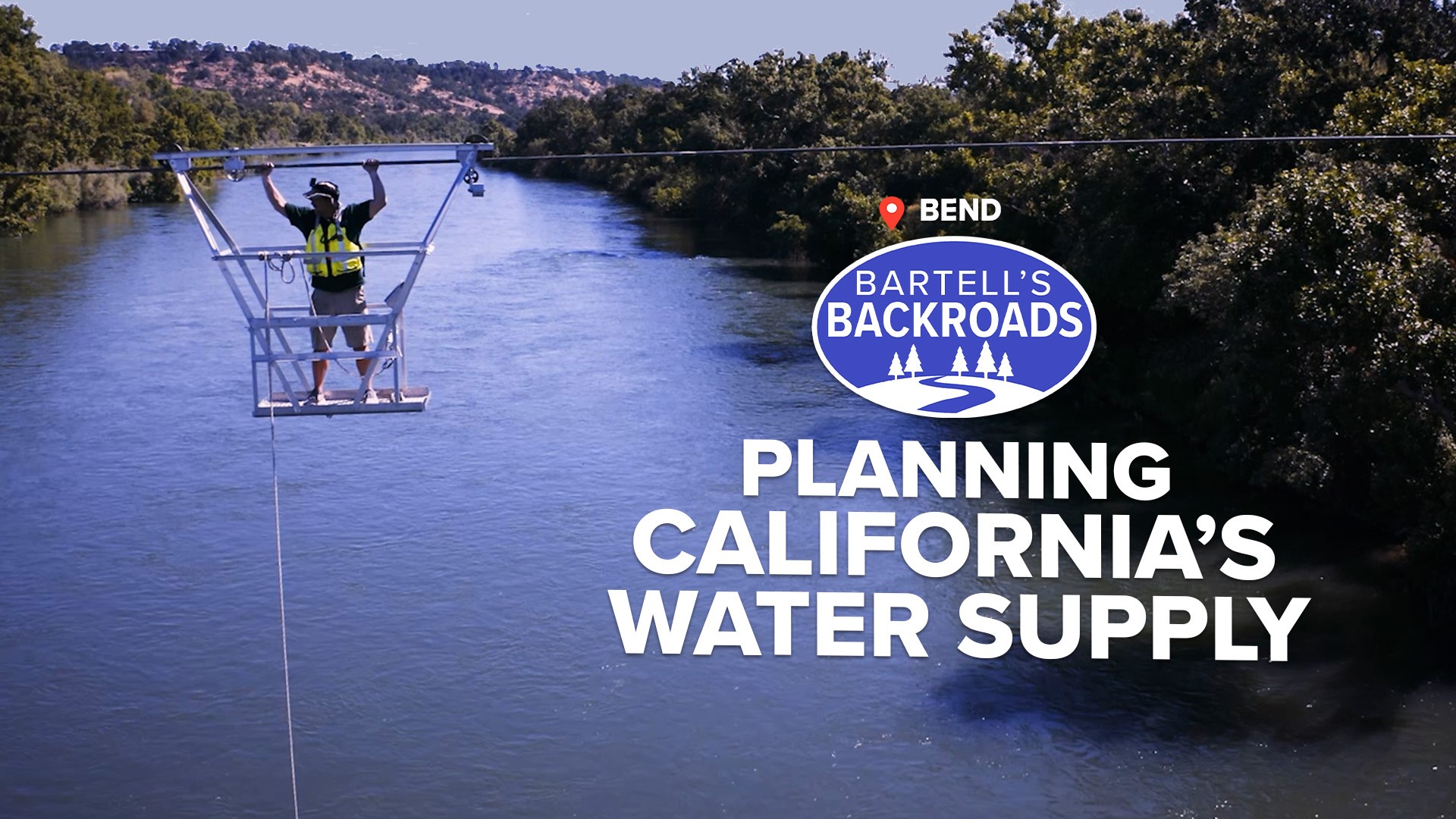
BEND, Calif. — Not everyone who works for the U.S. Geological Survey studies rocks or dirt, and that’s especially true for hydrologic technicians. These government workers actually study water, oftentimes from the air using what’s called a streamgage cableway.
California has one of the longest cableways on the West Coast: the Bend Streamgage Cableway over the Sacramento River. It’s located near the town of Bend about 45 miles south of Lake Shasta in Tehama County and its sole purpose is for the collection of water flow data.
The main function of a streamgage is to record how much and how fast water is moving. The USGS manages more than 11,800 streamgages across the U.S. but if you ask hydrologic technician Brandon Ledbetter, he will tell you the streamgage cableway is a pretty big deal — at least in California.
“It is over 1,000 feet to get to the other side and he’s up about 25 feet,” said Ledbetter while pointing to a colleague suspended over the river in a metal carrier. “[It's] the largest and most important... that may be a little biased, but rightfully so.”
The Sacramento River is California’s largest, providing 31% of the state’s surface water as far south as Los Angeles. Data collected from the Bend streamgage is used to decide when and how the water is used.
“Dam releases are measured from gages like ours,” said Ledbetter.
Lake Shasta is the largest dam on the Sacramento River and water reached historic lows during the drought years between 2020 and 2022. Thanks to data from streamgages, it never went dry.
“Obviously, the Shasta Dam [was] being drawn down less full, less full at the time, but we still had water because that was the plan. We planned for it,” said Ledbetter.
TAKE A TRIP ON BARTELL'S BACKROADS:
► See an interactive map of everywhere John has visited on the backroads
► Watch all of the Backroads videos
► Follow John on Facebook
Keeping water in the Sacramento River flowing at the correct level affects the entire state. Strong water flow from the Sacramento pushes back salt water from the San Francisco Bay. If water flow is too weak, salt water would get into the Delta, then possibly into the California aqueduct which provides drinking water to the Central Valley and Los Angeles.
“The Sacramento River is the most important river in the state and this is one of the main gages,” said Ledbetter.
During the winter and spring 2023, water in the Sacramento rose above the bank and over the highwater gage. Once again streamgages helped control water at the dam and warn people about flooding. At its peak, water flow was 115,000 cubic feet per second.
“That hasn’t happened since 2006,” said Ledbetter.
The USGS recognized the importance of recording stream flow data a long time ago.
“This cableway, the peak measurements have been recorded here since 1879, which was when the USGS was originally founded,” said Ledbetter.
In the 1800s, cableways and the streamgages were primitive. USGS workers would have to ride in a wooden box on a cable and use rulers to get data.
Today, water flow data is collected every 15 minutes from computer monitors planted in the river. The only time hydrologic technicians like Jon Ferguson and Cory Trent use the cableway is when they must calibrate computer sensors, which is once every six weeks. You can’t be afraid of heights to do this job, which suits Ferguson well.
“This is an E-ticket ride. This is fun!” said Ferguson.
Rivers change directions and depth all the time. To see how much the river changes and to get accurate readings, Ferguson drops a complex water flow recorder, which looks like a robot boogie board, in the Sacramento and Trent checks the data for the recorder with all the gages.
“That is why we come out. We are calibrating the elevation and... measuring the discharge,” said Trent.
Thanks to the snowfall and precipitation during the winter, water flows are looking really good.
“There is more than double the amount of water flowing than we did the past few years at this time,” said Ledbetter.
Farmers, cities, cargo ships and wildlife all depend on the Sacramento River, and dependable water flow depends on accurate data from streamgages.
“A lot goes into bringing water down to households and to grow our almonds that we all love," said Ledbetter.
ANOTHER WATERY ADVENTURE FROM THE BACKROADS | The floating highway: Riding the only state-run ferry system in California.


