SACRAMENTO, Calif. — It's been quite a start to July across Northern California. The last day of June kicked off this stretch of 100°+ heat and we've only been warming up since then.
We've been warning about this extreme heat, not only for how hot it is but for how long it'll last. We're only on day five of what could be 13 straight days with a high of 100°+.
Although days with highs in the low 100s aren't uncommon in Northern California, we usually don't see so many consecutively.
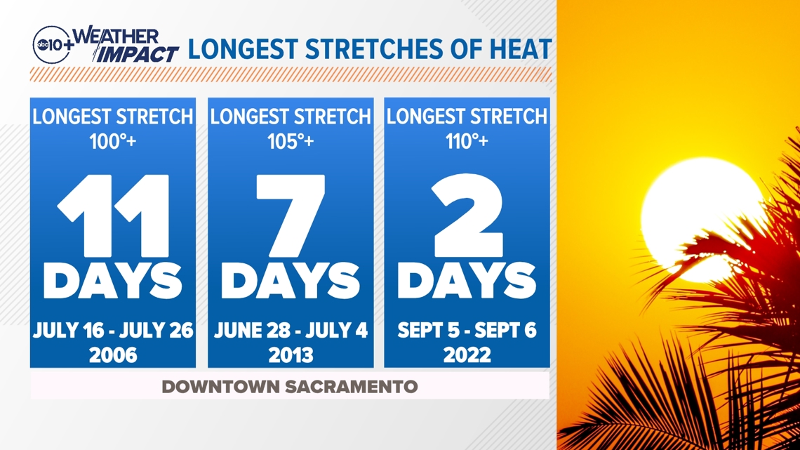
The record for longest 100°+ stretch for Downtown Sacramento is 11 days, which was set from July 16-26, 2006. The record for longest 105°+ stretch is about half as long — only seven days — between June 28-July 4, 2013.
Hitting 110° isn't even a certainty in Sacramento. We've only hit 110°+ in 10 different years since 1990. The longest consecutive run of 110°+ was set recently in September 2022. This was also when Sacramento recorded its hottest temperature ever at 116°.

This July could see one more more of those heat records fall.
A very strong Eastern Pacific high pressure is sitting overhead and not going anywhere. This is causing much above-average heat that will continue into the second week of July.
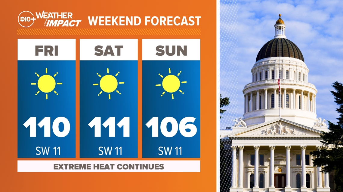
In fact, the days immediately after the 4th of July could end up being the hottest of the entire heatwave, with highs downtown expected to be at and above 110° Friday and Saturday. This is more than 15 degrees above average for the time of year.

While extreme heat is a type of natural disaster, this level of heat is what we might call an unnatural disaster.
For years, scientists have known about the effects burning coal, fossil fuels and other sources of greenhouse gases could have on our atmosphere and our climate. It wasn't until the last decade or so technology advanced enough that we could start doing real-time attribution science — the ability to connect the dots of climate change to the current weather.
While attribution science still has a ways to come with some other natural disasters such as severe thunderstorms, hurricanes and even atmospheric rivers, we can easily tie climate change to heatwaves.
One of the best ways to do this is by utilizing the Climate Central Climate Shift Index. This tool tells us on a scale of 1 to 5 how much more likely temperatures are to occur in our current climate vs a climate without added greenhouse gases. On the flip side, it can also tell us how much more unlikely temperatures are on a scale of -1 to -5.
If we look at the data for July 4, it paints a pretty stark picture: climate change is making our afternoon high temps near 110° at least 2x more likely, although for many areas it's closer to 4-5x more likely.
Climate Shift Index for July 4, 2024

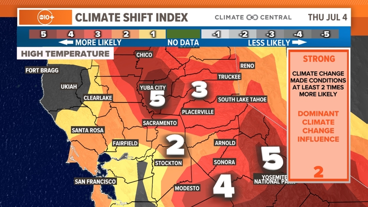

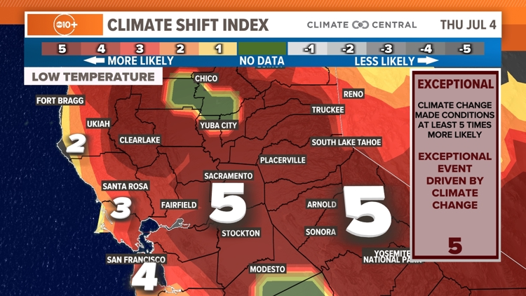
The data is even more striking when looking at the effect climate change is having on our overnight temperatures. The Climate Shift Index is a widespread 5 out of 5 from the Coastal Range to the valley and in the Sierra. This means the very warm overnight lows are made at least 5x more likely due to climate change. In other words, this is an exceptional heat event driven by climate change that would be almost impossible to accomplish without human-caused climate change.
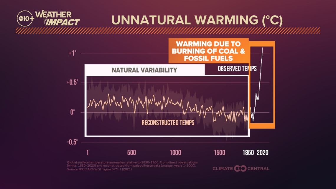
This shift towards an overall warmer climate is due to the fossil fuel boom that happened after the Industrial Revolution in the mid to late 1800s. As humanity placed greater and greater emphasis on fossil fuels – first coal and now oil – we increased the amount of pollution into our atmosphere. This has fundamentally changed the way our climate operates.
There has always been natural variability in the Earth's atmosphere. Using ice cores and tree rings and various other ways, climatologists are able to reconstruct what our climate was like going back thousands of years. As you might expect, the level of carbon dioxide (CO2) in the air historically ebbed and flowed, leading to periods of warmer temps and cooler temps.
However, as humans have pumped massive amounts of CO2 into the atmosphere for now well over 100 years, the climate has undergone a rapid and intense period of unnatural warming.

As our climate warms, our baselines are changing. What would've been considered normal in the early 1900s is now extremely unlikely due to our climate warming up.
Look at the image below. This is what's known as a Bell Curve, something you might be familiar with from college. In this case, the Bell Curve is plotting temperatures. The most common temperatures – our averages – fall in the tallest part of the curve. The more uncommon temperatures – extreme heat or extreme cold – happen on the edges.
As our climate warms, our baseline shifts. So what would've been considered extreme heat in the early 1900s is now considered more normal. This also means that previously unthinkable high temperatures – like 130°F at Death Valley – are now much more likely than 100 years ago.

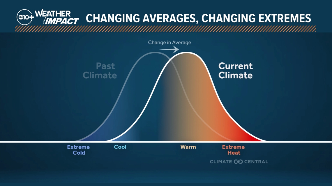
Climate change doesn't mean we can't see periods of colder than average temperatures or even record cold snaps. Just as an example, ask any Texan that lived through the February 2021 winter storm. Climate change just means that we are much less likely to see cold snaps compared to 100 years ago.
This heatwave may be a sign of things to come for Northern California. Only time will tell. California has always been a land of weather extremes, but our extremes are becoming more extreme.
WATCH MORE ON ABC10 | California Extreme Heat Wave Forecast: Brutal 100s aren't going anywhere for now