SANTA BARBARA COUNTY, Calif. — Click here for the latest updates on the Lake Fire.
A wildfire, called the Lake Fire, is causing evacuations in Santa Barbara County, California.
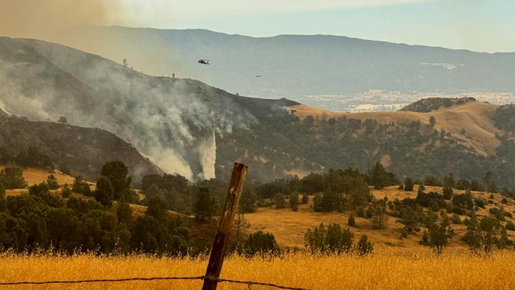
It's now the largest active fire in California burning more than 26,000 acres and 12% contained as of Tuesday morning, according to Cal Fire.
It grew more than 4,000 acres overnight as the blaze was around 21,700 acres as of 7 p.m. Monday. Cal Fire said overnight water drops prevented the fire from making significant growth. Fire activity continued on the east side of the fire with significant smoke and expanded evacuation orders for remote areas.
The priority for crews is to prevent the fire from moving towards communities in the south. A Red Flag Warning was issued for the fire area with strong winds and hot, dry conditions expected.
The fire started July 5 around 3:45 p.m. near Zaca Lake. It grew quickly, burning through grass and brush amid the prolonged heat wave.
The fire is threatening about 500 structures and one structure has been damaged, according to Cal Fire. Damage assessments are ongoing. Three firefighters have been injured in the fire, but the severity of the injuries is unclear.
The cause of the fire is under investigation.
EVACUATIONS
Evacuation orders: Parts of the Figueroa Mountain area as follows: south of Tunnel House at Sisquoc River, east of Figueroa Creek, north of the southern end of Cachuma Mountain, and west of Los Padres National Forest areas.
Evacuation warnings: Area of Goat Rock, east of Figueroa Creek, north of the US Forest Service entrance at Happy Canyon Road, and south of Cachuma Mountain.
There's a shelter at Solvang Veterans Memorial Hall at 1745 Mission Drive.
Road Closures:
- Happy Canyon Road at the Forest Service Boundary
- Foxen Canyon Road at the Zaca Station Road and Alisos Canyon Road
- Figueroa Mountain Road at Midland School
Here's a map of evacuations.
STAY INFORMED
FIRE MAP
This map from the National Interagency Fire Center shows fire activity (this may take a few seconds to load):
WILDFIRE PREPS
If you live in a wildfire-prone zone, Cal Fire suggests creating a defensible space around your home. Defensible space is an area around a building in which vegetation and other debris are completely cleared. At least 100 feet is recommended.
The Department of Homeland Security suggests assembling an emergency kit that has important documents, N95 respirator masks, and supplies to grab with you if you’re forced to leave at a moment’s notice. The agency also suggests signing up for local warning system notifications and knowing your community’s evacuation plans best to prepare yourself and your family in cases of wildfires.
Some counties use Nixle alerts to update residents on severe weather, wildfires, and other news. To sign up, visit www.nixle.com or text your zip code to 888777 to start receiving alerts.
PG&E customers can also subscribe to alerts via text, email, or phone call. If you're a PG&E customer, visit the Profile & Alerts section of your account to register.
What questions do you have about the latest wildfires? If you're impacted by the wildfires, what would you like to know? Text the ABC10 team at (916) 321-3310.
For more ABC10 Wildfire coverage on your time, stream ABC10+ on your TV for free:
► Roku - click here
► Amazon Fire - click here
► Apple TV - click here
Watch more on ABC10 | Royal Fire in Tahoe National Forest: 13 hikers missing in fire zone found