Structures were damaged or destroyed by the King Fire in the White Meadows area, Cal Fire spokesperson Larry Pendarvis said Friday.
It's unknown how many homes or buildings have been destroyed because damage assessment crews have not been able to get in due to the ongoing risks in the area.
There are still a number of active fires and smoldering hot spots. Fire crews were seen Friday strengthening control lines.
Downed power lines are also concern, even though PG&E has shut off all the power in the area.
"Even staying away from the poles themselves," King Fire PIO Mike McMillan explained. "Some of those are compromised so bad it's a matter of time before those fall by themselves unless we take them down first."
Crews went into the area Friday afternoon to assess the losses. They and El Dorado County sheriff's personnel will notify property owners of what they find.
County officials said White Meadows property owners could also call (530) 642-7263 or send an email to Kingfireeldoradocounty@gmail.com to get information about the status of their property.
Health cautionary advisory
Smoke from the fire prompted area air officials to issue a health cautionary statement for San Joaquin, Stanislaus, Merced, Madera, Fresno, Tulare, King counties and the Valley air basin portion of Kern County. Smoke from fires produces fine-particulate matter (PM2.5), which can cause serious health problems -- including lung disease, asthma attacks and increased risk of heart attacks and stroke.
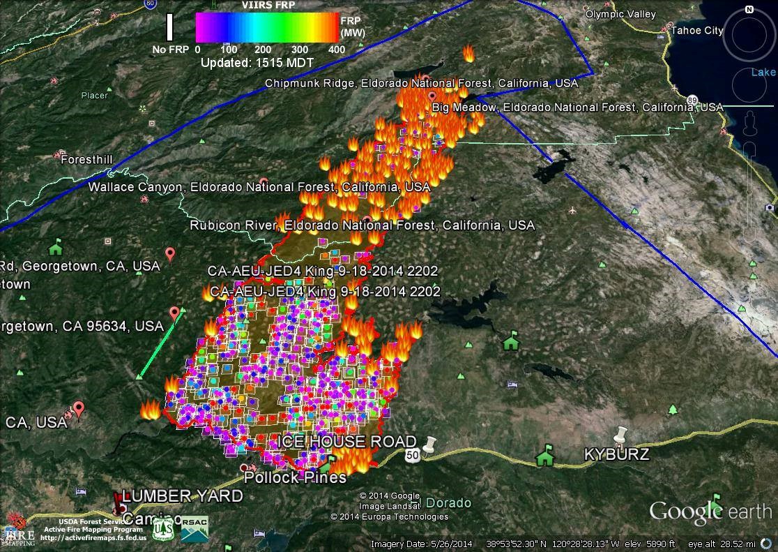
The fire grew 5,432 acres between Thursday morning and Friday morning to cover a total of 76,376 acres near Pollock Pines and areas to the northeast, according to a California Interagency Incident Management Team Tweet. The team includes representatives from federal, state and local agencies that manage and battle large wildfires.
Officials leading the effort to battle the fire issued this update Friday:
The King Fire is burning in steep terrain in the South Fork of the American River Canyon, Silver Creek Canyon, and the Rubicon canyon, north of the community of Pollock Pines. Last night the fire backed down into the canyons with the evening down slope winds. With the warmer and drier weather today, the fire is expected to be more active with spot fires up to half-mile ahead of the fire in the afternoon. The winds today are predicted to come from the east, which is a concern as it could result in increasing fire behavior on the western front.
Containment improved from 5 percent Thursday morning to 10 percent Thursday evening, according to Cal Fire.
A total of 21,000 structures were threatened: 12,000 single residences and 9,000 other minor structures, Cal Fire said. More than 2,800 people have been evacuated from their homes.
The fire began Saturday near Pollock Pines, about 60 miles northeast of Sacramento. Wayne Allen Huntsman, 37, of Pollock Pines, was arrested Wednesday and charged Friday with arson and special allegations in connection to the blaze. He is being held in El Dorado County Jail on $10 million bail, according to the jail website.
RELATED STORY: King Fire arson suspect pleads not guilty
Mandatory evacuations as of 6 p.m. Thursday were in place for:
- Crystal Basin area: Hwy. 50 east of Fresh Pond to Ice House, north on Ice House Road to Wentworth Springs, west to just above Quintette, to include campgrounds and businesses:
- Union Valley Reservoir area
- Yellow Jacket Campground
- Wolf Creek Campground
- Stumpy Meadows Campground
- Fashoda Campground
- Big Hill Lookout Road
- Big Hill Road
- Blodgett Forest Road
- Bridle Path Way
- Forest Road
- Frontier Road
- Helix Flat Ave
- Icehouse Road (west side)
- Jones Fork Power House Road
- Middle Loop Road
- Mosquito Road
- Onion Valley Road
- Outer Limits Lane
- Little Silver Road
- Loop Road
- Peavine Point Road
- Peavine Ridge Road
- Plum Creek Road
- Piolet Creek Road
- Robbs Peak Road
- Sand Mountain Road
- SMUDEA (permittee site)
- Spring Road
- Sunset Drive
- Tricometric Trail
- Wentworth Springs (south side, east of Pilot Creek Road)
- 11 Pines Road
- The entire community of Swansboro, north of the South Fork of the American River between Brushy Creek and Rock Creek.
- The eastside of Forebay Road from King of the Mountain Road to Pony Express Trail. All roads north of Pony Express Trail from Forebay Road east through Bullion Bend. White Meadows Road and Spring Valley Road.
Voluntary evacuations as of 6 p.m. are in place for Volcanoville, Quintette, and residents located west of Forebay Road from Blair Road to Pony Express Trail. Additional voluntary evacuations are in place for:
- Badger Hill Road
- Marmot Road
- Lucky Mine Road
- Old Blair Mill Road
- Apple Creek Court
- Applemont Ranch
- Chickaree Lane
- Longs Creek
- Quick Silver Road
- Quick Silver Court
- Baltimore Road
An evacuation shelter has been set up at Camino Seventh-day Adventist Church, 3520 Carson Road, Camino, 95709. Another center has been set up in South Lake Tahoe at 1180 Rufus Allen Boulevard.
How you can help:
The American Red Cross is collecting donations to help residents directly impacted by the King Fire. You can donate online at RedCross.org or you can mail or drop off donations at 1565 Exposition Boulevard., Sacramento, 95818.