
SACRAMENTO, Calif. — It's been a long and hot summer across Northern California. Now that it's October, the 2023-2024 water year has ended and a new one has begun. The rain and snow of last winter feels like a distant memory, and many of us are looking forward to some cooler and wetter weather returning.
In the near-term, the weather pattern looks to remain warm and dry, with high pressure controlling the setup. But what about the rest of fall and into the winter? Can we say what lies ahead for Northern California in water year 2024-2025?
As we know, it's impossible to forecast exact numbers this far out, but there are some tools we can use to make an informed estimation of what the next few months may look like.

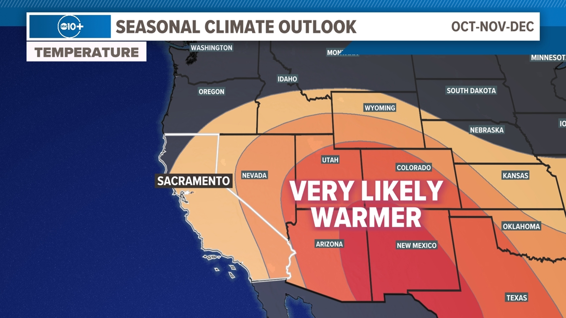
The NWS Climate Prediction Center uses a myriad of climate models and long-term pattern influencers (like El Niño/La Niña, more on that in a minute) to make an educated estimate of the next several months.
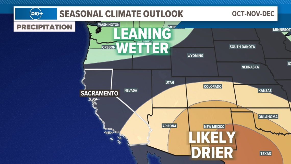
In our case, the CPC is expecting Northern California to see mostly above average temperatures from October through November, and a near-average rainfall pattern through the same timeframe.
These outlooks don't tell us about the day-to-day weather, so we can have stretches of cooler to cold weather and some wet days. However, the data suggests to us that we're likely to see more drier and warmer days than any other sort.

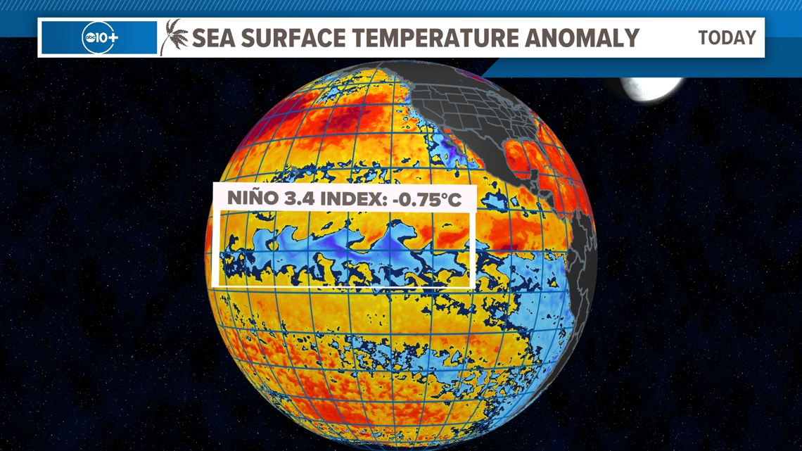
One of the most significant signals we look at when building these seasonal forecasts is the El Niño Southern Oscillation, or ENSO. ENSO is the periodic warming and cooling of equatorial Pacific sea surface temperatures (SSTs). The changing of SSTs impacts the weather patterns during the Northern Hemisphere winter and Southern Hemisphere summer.
What we're currently seeing across the equatorial Pacific is cooler than normal sea surface temperatures, indicating a La Niña pattern. This pattern is expected to continue through the fall, resulting in a weak to moderate La Niña during the winter months.

La Niña is the cool phase of ENSO, and typically means much of the southern United States receives a warm winter with below average rainfall. This is true for Southern California as well due to high pressure typically sitting closer to the U.S. west coast.
During La Niña, the northern Great Plains are typically colder than usual as the polar jet drops low across the U.S. The Pacific Northwest and far Northern California usually get above-average precipitation winters with frequent landfalling atmospheric rivers.

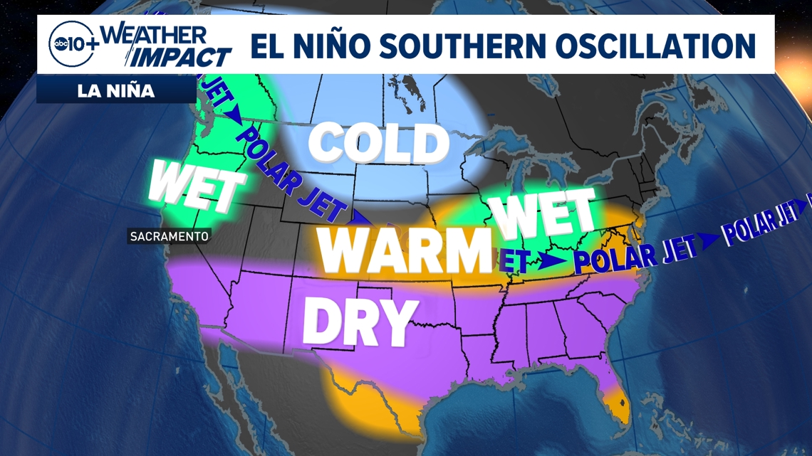
But for the Capital Region, Bay Area, and Central Sierra of Northern California, the outlook is trickier. During La Niña winters, this area — roughly the Interstate 80 corridor — is in an area where sometimes La Niña results in above average winters (like in 2016-17 and 2022-23) but can also result in below average winters (like in 2020-21 and 2021-22).
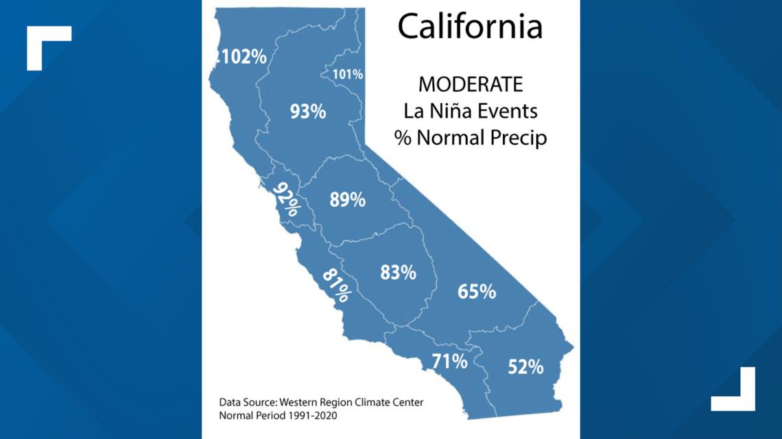
The map below shows which regions of California see above and below average rainfall during moderate La Niña events, like what is expected develop this winter. Like we talked about above, a drier than average winter for Southern California is very common during moderate La Niña events, and far Northern California typically picks up a near to above average season.
Again, the Interstate 80 corridor is somewhat in-between. The Sacramento Valley, Bay Area and San Joaquin Valley will typically pick up about 90% of average during moderate La Niña events.

It should again be noted La Niña isn't the end-all, be-all of what the winter season holds. There have been years La Niña resulted in extremely dry winters, but also extremely wet winters, so we also have to look at other areas.
Just as we use weather models to show incoming rain, snow, wind, etc., there are long-term models that go out several months. These models are known as climate or seasonal models since they aren't telling us day-to-day weather so much as they're giving us a look at overall patterns for a month or season.
The National Weather Service and the European Center for Medium-Range Weather Forecasts (ECMWF or Euro) both run seasonal models that are publicly available and widely respected.

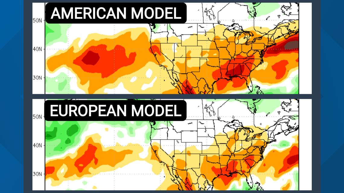
The latest versions of the American and European models (see above) both show California and the southern United States may receive below average rainfall between October and December, while the Pacific Northwest likely sees above average rainfall. Sound familiar? These are hallmarks of La Niña.
Again, keep in mind these don't tell us what the weather will be like on October 20, Thanksgiving or any specific day. These seasonal models show us what the overall weather pattern (influenced by ENSO) may look like over the course of 30 or 90 days. They can be wrong, but we're just looking to get an idea.
There is another weather pattern that plays quite a role in West Coast weather - the Pacific-North American Pattern (PNA). This pattern is only good for use within about 14 days, which isn't good for seasonal forecasts but is very helpful when we get into the thick of winter and we're searching for incoming atmospheric rivers.

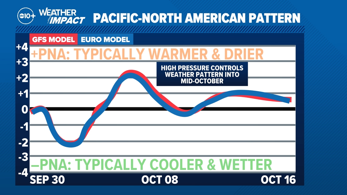
The PNA is either negative or positive. When it's negative, high pressure moves well away from the California coast and opens the proverbial "storm door" for Northern California, allowing for atmospheric rivers to make landfall in our area.
When the PNA is positive, the high pressure sits off the coast or even right overhead, keeping the storm door closed and steering atmospheric rivers into the Pacific Northwest or even British Columbia.
Looking into the middle of October, the PNA stays largely positive, indicating high pressure will have control over the weather pattern for the foreseeable future.

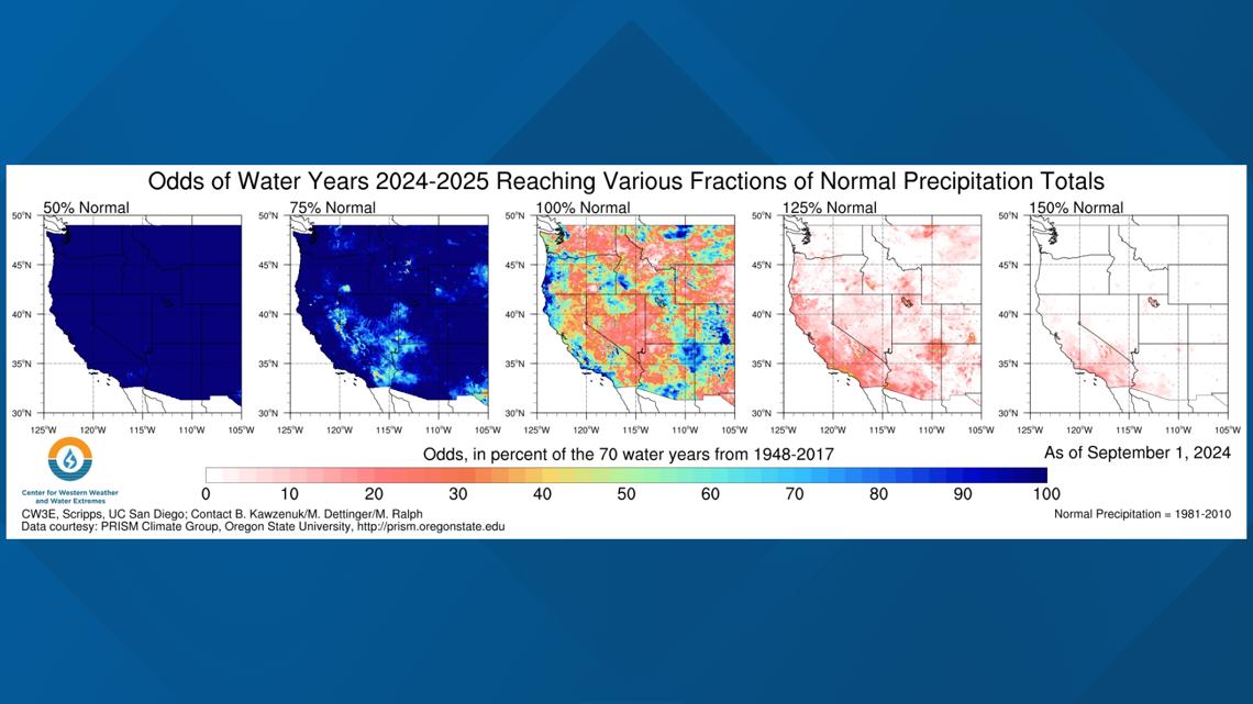
One more tool we can use to look ahead into the new water year is the Center for Western Weather and Water Extremes, or CW3E, based at Scripps at UC San Diego in La Jolla. CW3E does a ton of great work on California weather and water, especially as it relates to atmospheric rivers. You may have seen us use CW3E data in our weather forecasts. They're a bit like the California equivalent of the NWS National Hurricane Center.
CW3E modeling currently shows much of California with a very high chance (>90%) of the 2024-2025 water year being at least 75% of normal. For Sacramento, that would mean roughly 14 inches of rain. However, the chances of most of the state getting an average water year is not nearly as high, only about 20-50%. And the chances of an above average season? At least according to the CW3E data, less than 10-20% for most of the state.
As we discussed above, this is not unexpected with a La Niña winter forecast. La Niña winters are typically — not always, but usually — drier than average.
So with all of these things being said, what's the takeaway heading into the wetter season? Being this far out, we're limited in what we can say. However, based on past La Niña events and seasonal weather models, it's likely to be warmer and with less rain and Sierra snow than usual.
Does it mean we'll be facing low reservoirs and growing drought by the spring? Not at all! Seasonal weather modeling is one of the toughest things in meteorology. We take a look at these things to give us an early heads up. As we always say, stay tuned for the latest.


