SACRAMENTO, Calif. —
In what continues to be an unusual weather year, extreme heat continues to evade Northern California.
Sacramento typically sees its first 100-degree day in mid June, but the closest the capital city has gotten so far this year was 96 degrees, on May 13 and June 4.
Instead, weather patterns promoting cooler than average temperatures and higher rain chances have dominated the pattern. Low pressure after low pressure system have spun up over the California coast, and the results have been cooler temperatures, daily Sierra thunderstorms and above-average cloud cover.
High temperatures on Monday will be around 80 in Sacramento and partly to mostly cloudy skies will prevail. The warming trend will push high temperatures into the mid 80s in the valley on Tuesday, upper 80s on Wednesday and Thursday and low 90s by Friday and Saturday. In the Sierra, expect 60s for the first half of the week and 70s by the end of the week and into the weekend.
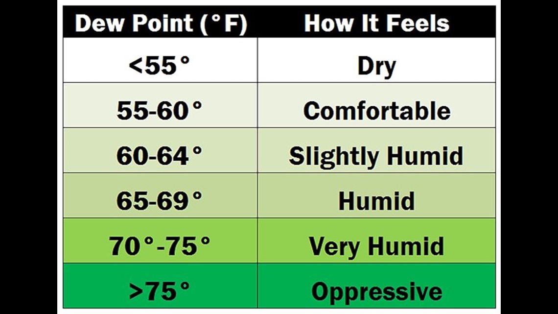
Throughout the week, dew points – a measure of moisture in the air – will be elevated throughout the week. For California standards, it may feel slightly humid at times this week as dew points will be near 60 degrees. The moisture will also help fuel Sierra storms, at least in the first half of the week before chances die down on Wednesday and beyond. So far this month, most Sierra locations are at least 300% above average in terms of precipitation.

The highest temperatures of this week will occur on Friday and Saturday when the influence of high pressure is greatest. A drop in temperature can be expected on Sunday as the next weather feature, a stronger low pressure system, will drop down into Northern California from the north. This system will bring in drier air and gusty winds, along with once again dropping temperatures to below average across Northern California by early next week.
WATCH ALSO: