
EL DORADO COUNTY, Calif. — Click here for Monday's update.
The Caldor Fire, burning for a week in Northern California, has seen its first increase to containment.
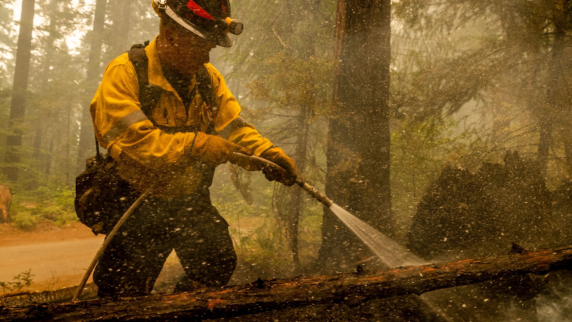
There's 5% containment Sunday of the Caldor Fire, which had charred nearly 154 square miles of trees and brush in the northern Sierra Nevada after breaking out Aug. 14.
Firefighters hoped to take advantage of calmer weather and cooler temperatures a day after gusts pushed the fire across U.S. Route 50, threatening more remote communities in El Dorado County. According to Tim Ernst, Operations Sections Chief for Cal Fire, the closure came in just in time as the fire spotted across the highway on Saturday. He said the spot fire grew to 200 acres, which could have caused impacts to traffic safety.
In an evening update from Cal Fire, Will Harris, with the U.S. Forest Service, said the fire is currently holding south of Highway 50. Other than the prior spot fire, Harris said there have been no new spot fires north of the highway. There is no current timeline for when Highway 50 might reopen.
As of 8 a.m. Sunday, the Caldor Fire has forced 24,500 people out of their homes in El Dorado County, according to Cal OES. Incident Commander Dusty Martin said there is still no timeline for when evacuations might lift.
Some evacuees were camping in tents and trailers Saturday night in a winery parking lot just off Highway 50 in the Camino area. Many of them were neighbors from Pollock Pines, trying to keep together and be there for one another during an uncertain time.
Mike Gerondakis has been out of his home for about five nights. He's been staying in the winery parking lot close to the evacuation line, surrounded by about 20 of his neighbors who decided to set up camp as well. They've been getting help through the hardship from complete strangers trying to lend a helping hand.
"They’re coming out and saying, 'you want tents? Sleeping bags? What do you want? We got it all.' I mean one guy comes over says we’ll bring you over ice and he brings over 50 pounds of ice,” Gerondakis said.
For Gerondakis and the other evacuees, it'll be a waiting game until they learn when they can return home as the firefight against the Caldor Fire stretches on.
The blaze has consumed 104,309 acres with 5% containment. 345 homes have been destroyed along with six commercial properties and 124 minor structures. Priority areas in the firefight include an area by the origin point in the southwest corner of the fire, which is seeing the fire push into a drainage of the Consumnes River. Ernst said the growth is a threat due to a potential push toward housing areas near Caldor, Grizzly Flats, and Blue Mountain.
Some changes to the fire map are also expected as firefighters move their operations out of Strawberry Creek to Highway 89 to find new places to fight the fire from. Chief Mike Blankenheim emphasized that crews don't intend to let the fire get to Highway 89 and that people living around Highway 89 won't see an changes to evacuations in the immediate future.
Evacuations and Road Closures
Click HERE for in-depth evacuation orders and warnings in El Dorado County. For evacuation orders and warnings in Amador County, click HERE for the Amador County Sheriff's Facebook page and HERE for their website. For current state highway/route information visit roads.dot.ca.gov.
Evacuation centers
- Green Valley Community Church3500 Missouri Flat Road, Placerville, CA
- Evelynn Bishop Hall 701 Hwy 124, Ione, CA
- Rolling Hills Church 800 White Rock Road, El Dorado Hills, CA
- Douglas County Community Center 1329 Waterloo Lane, Gardnerville, NV
Shelter Full -- Cameron Park CSD 2502 Country Club Drive, Cameron Park, CA
Temporary Evacuation Point -- Amador County Fairgrounds 18621 Sherwood Street, Plymouth, CA
Animal Evacuation Centers:
- El Dorado County Animal Services: Call (530)-621-5795 (Small animals)
- Large Animal Shelter Amador County Fairgrounds 18621 Sherwood St., Plymouth (530)621-5795 or (530)647-6227
- Saureel Vineyards (large animals) 1140 Cold Springs Road Placerville, CA (530) 621-5795
Accounts to follow
Evacuation Maps
A map of evacuations from the El Dorado County Sheriff's Office is available below.
Wildfire map
Structure Damage Map
A map of structural damage from the El Dorado County Sheriff's Office is available below.
►Stay in the know! Sign up now for the Daily Blend Newsletter
What questions do you have about the latest wildfires? If you're impacted by the wildfires, what would you like to know? Text the ABC10 team at (916) 321-3310.
Wildfire Preps
If you live in a wildfire-prone zone, Cal Fire suggests creating a defensible space around your home. Defensible space is an area around a building in which vegetation and other debris are completely cleared. At least 100 feet is recommended.
The Department of Homeland Security suggests assembling an emergency kit that has important documents, N95 respirator masks, supplies to grab with you if you’re forced to leave at a moment’s notice. The agency also suggests signing up for local warning system notifications and know your community’s evacuation plans best to prepare yourself and your family in cases of wildfires.
Some counties use Nixle alerts to update residents on severe weather, wildfires, and other news. To sign up, visit www.nixle.com or text your zip code to 888777 to start receiving alerts.
PG&E customers can also subscribe to alerts via text, email, or phone call. If you're a PG&E customer, visit the Profile & Alerts section of your account to register.
WATCH ALSO:


