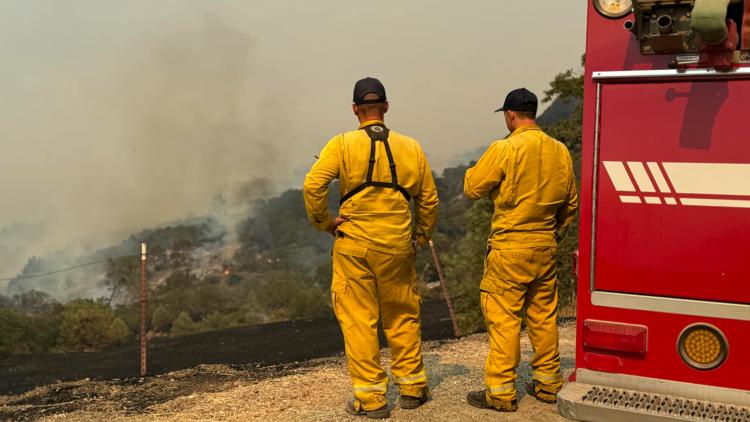
SANTA BARBARA COUNTY, Calif. — The Lake Fire in Santa Barbara County has burned nearly 37,000 acres as of Friday.
It's the largest active wildfire in California and is 16% contained, according to Cal Fire. Crews will continue extinguishing hot spots and working to improve containment lines. Cal Fire said this fire has grown in complexity and has been divided into two zones to make sure operational functions are met.
About 2,166 people are impacted by evacuation orders and warnings as of Thursday, according to the Santa Barbara County Sheriff's Office.
Excessive heat warnings are in effect until Saturday with temperatures expected to be between 90-100 degrees in the fire area. Cal Fire said the fire is active and parts of the fire are moving to areas with no recorded fire history.
Cal Fire said the fire perimeter is about eight to nine miles from Los Olivos as of Wednesday. Crews are working to prevent the fire from moving south toward communities.
The fire started July 5 around 3:45 p.m. at Santa Lucia Road near Zaca Lake. It grew quickly, burning through grass and brush amid the prolonged heat wave.
The fire is threatening about 794 structures, three recreational buildings have been destroyed and a campground is damaged, according to Cal Fire. Damage assessments are ongoing. Five firefighters have been injured in the fire, but the severity of the injuries is unclear.
The cause of the fire is under investigation.
EVACUATIONS
Evacuation orders:
- The area east of La Brea Creek and Forest Route 10N06, south of the Los Padres National Forest boundary, and north of the Sisquoc River
- Woodstock (Areas north of Calzada Ave, east of E. Oak Trail Rd., west of Happy Canyon, and south of the Sisquoc River)
- Goat Rock Areas (Area of Goat Rock, east of Figueroa Creek, north of the US Forest Service entrance at Happy Canyon Road, and south of Cachuma Mountain)
- SB Ranger area (remote forest area east of Goat Rock)
- Parts of the Figueroa Mountain area as follows: south of Tunnel House at Sisquoc River, east of Figueroa Creek, north of the southern end of Cachuma Mountain, and west of Los Padres National Forest areas
- All areas from Figueroa Mountain Road at Junction Camp (including Tunnel Rd) to Chamberlin Ranch and all areas from Zaca Lake Rd at Foxen Canyon Road north to the Sisquoc River including east of Foxen Canyon Road to the 9000 block.
Evacuation warnings:
- Area east of Kelly Canyon, north of Sisquoc River, west of La Brea Creek and Forest Route 10N06, and south of the Los Padres National Forest.
- Area starting at the south end of Cachuma Creek, northeast of Santa Cruz Creek to Santa Cruz Peak, west through Grand Spring, and to the northern part of Cachuma Creek.
- Area east and north of Alisos Rd (L-shaped road), west of Cachuma Creek, and south of the US Forest Service entrance at Happy Canyon Road.
- Area east of Highway 154, north of Armour Ranch Road/Secretariate St, west of Alisos Rd, and south of the Woodstock area.
- Area east of Figueroa Mountain Road, north of Highway 154, west of Calzada Ave/W Oak Trail Rd and south of Woodstock Rd.
Here's a map of evacuations.
ROAD CLOSURES
Find a map of current road closures HERE.
- Happy Canyon Road: Closed at forest boundary due to Lake Fire.
- Foxen Canyon Road: Closed at Zaca Station Road and Tepusquet Road due to the Lake Fire.
- Figueroa Mountain Road: Closed at Midland School due to Lake Fire.
- Old San Marcos Road: Closed due to Caltrans closure of Highway 154.
STAY INFORMED
FIRE MAP
This map from the National Interagency Fire Center shows fire activity (this may take a few seconds to load):
WILDFIRE PREPS
If you live in a wildfire-prone zone, Cal Fire suggests creating a defensible space around your home. Defensible space is an area around a building in which vegetation and other debris are completely cleared. At least 100 feet is recommended.
The Department of Homeland Security suggests assembling an emergency kit that has important documents, N95 respirator masks, and supplies to grab with you if you’re forced to leave at a moment’s notice. The agency also suggests signing up for local warning system notifications and knowing your community’s evacuation plans best to prepare yourself and your family in cases of wildfires.
Some counties use Nixle alerts to update residents on severe weather, wildfires, and other news. To sign up, visit www.nixle.com or text your zip code to 888777 to start receiving alerts.
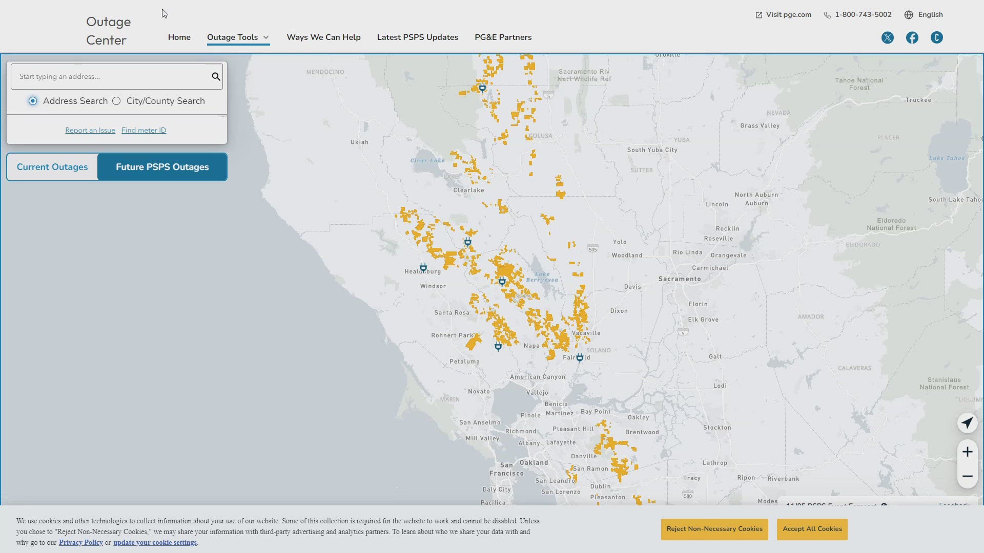
PG&E customers can also subscribe to alerts via text, email, or phone call. If you're a PG&E customer, visit the Profile & Alerts section of your account to register.
What questions do you have about the latest wildfires? If you're impacted by the wildfires, what would you like to know? Text the ABC10 team at (916) 321-3310.
For more ABC10 Wildfire coverage on your time, stream ABC10+ on your TV for free:
► Roku - click here
► Amazon Fire - click here
► Apple TV - click here
Watch more on ABC10 | Royal Fire in Tahoe National Forest: 13 hikers missing in fire zone found