PLUMAS COUNTY, Calif. — Click here for the latest updates on the wildfires in Plumas County.
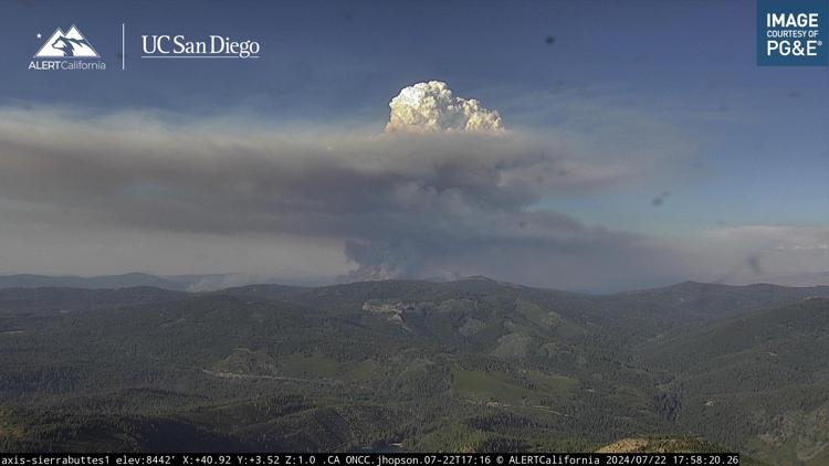
Firefighters in the Plumas National Forest are currently fighting multiple fires believed to be started by lightning.
The so-called Mill, Mill 2 and Mill 3 fires are burning near Whitehawk Ranch. The first is the largest. The U.S. Forest Service-Plumas National Forest says the Mill Fire is about 500 acres, while the Mill 2 and Mill 3 fires are each estimated to be approximately 75 acres.
The Smith Fire is north of Highway 70 between Smith Peak and Maybe. The Fire is said to be about 50 acres.
The U.S. Forest Service says people in Whitehawk Ranch, Gold Mountain, Clio, Delleker, Lake Davis Area and the south side of Portola should have a go bag ready.
People should avoid the area and watch for firefighter traffic.
Evacuations
A map of evacuations can be viewed below.
The American Red Cross California Gold Country Region says an evacuation shelter at Quincy High School is open for those in need. The address is 6 Quincy Junction Road, Quincy, CA 95971 for those impacted by the fires.
Fire Map
This map from the National Interagency Fire Center shows fire activity (this may take a few seconds to load):
WILDFIRE PREPS
If you live in a wildfire-prone zone, Cal Fire suggests creating a defensible space around your home. Defensible space is an area around a building in which vegetation and other debris are completely cleared. At least 100 feet is recommended.
The Department of Homeland Security suggests assembling an emergency kit that has important documents, N95 respirator masks, and supplies to grab with you if you’re forced to leave at a moment’s notice. The agency also suggests signing up for local warning system notifications and knowing your community’s evacuation plans best to prepare yourself and your family in cases of wildfires.
Some counties use Nixle alerts to update residents on severe weather, wildfires, and other news. To sign up, visit www.nixle.com or text your zip code to 888777 to start receiving alerts.
PG&E customers can also subscribe to alerts via text, email, or phone call. If you're a PG&E customer, visit the Profile & Alerts section of your account to register.
What questions do you have about the latest wildfires? If you're impacted by the wildfires, what would you like to know? Text the ABC10 team at (916) 321-3310.