GORMAN, Calif. — Find the latest updates on the Post Fire HERE.
Strong winds are pushing flames from the so-called Post Fire through dry brush in mountains along Interstate 5 north of Los Angeles.
Officials on Sunday warned residents in the fire’s path to be prepared to leave if the blaze explodes in size again.
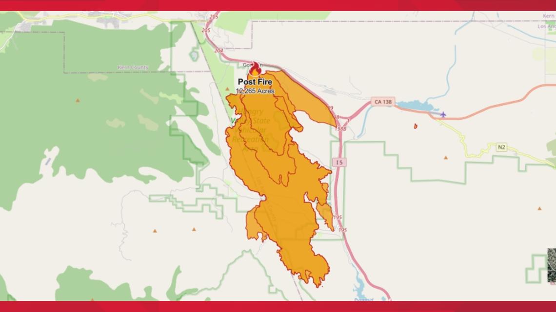
LA County’s first major wildfire of the year swiftly grew to more than 19 square miles, one day after it forced the evacuation of at least 1,200 campers, off-roaders and hikers from a recreation area.
The blaze was just 2% contained. No injuries are reported. Low humidity and gusts around 50 mph are expected throughout the day.
The Southern California fire erupted Saturday afternoon near I-5 in Gorman, about 60 miles (100 kilometers) northwest of Los Angeles. Two structures burned within the evacuated recreation area.
Evacuations for Post Fire
An evacuation map for the Post Fire in Los Angeles County can be viewed below.
Fire Activity Map
This map from the National Interagency Fire Center shows Post Fire activity (this may take a few seconds to load):
Cal Fire Perimeter Map
A fire perimeter map for the Post Fire was updated by Cal Fire around 2 p.m. Sunday.


Traffic Map
A traffic map of the area from ABC10 is available below.
WEATHER MAP
Radar map from ABC10.com. You can tap "locations" in the bottom left corner to find your specific area. Adjust the layers with a filter on the bottom right corner to show heat, wind and other conditions:
WILDFIRE PREPS
If you live in a wildfire-prone zone, Cal Fire suggests creating a defensible space around your home. Defensible space is an area around a building in which vegetation and other debris are completely cleared. At least 100 feet is recommended.
The Department of Homeland Security suggests assembling an emergency kit that has important documents, N95 respirator masks, and supplies to grab with you if you’re forced to leave at a moment’s notice. The agency also suggests signing up for local warning system notifications and knowing your community’s evacuation plans best to prepare yourself and your family in cases of wildfires.
Some counties use Nixle alerts to update residents on severe weather, wildfires, and other news. To sign up, visit www.nixle.com or text your zip code to 888777 to start receiving alerts.
PG&E customers can also subscribe to alerts via text, email, or phone call. If you're a PG&E customer, visit the Profile & Alerts section of your account to register.
What questions do you have about the latest wildfires? If you're impacted by the wildfires, what would you like to know? Text the ABC10 team at (916) 321-3310.
WATCH ALSO:


