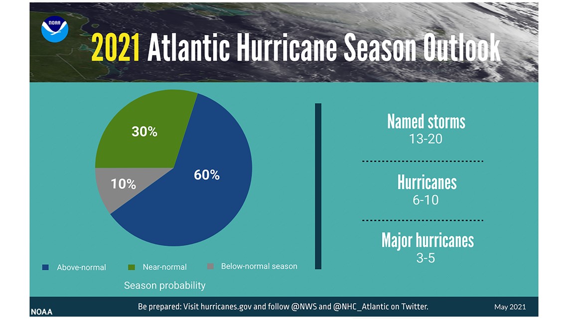
Ahead of the 2021 hurricane season, forecasters with the National Oceanic and Atmospheric Administration (NOAA) predicted this season would be an “above-normal Atlantic hurricane season”.
Hurricane season spans from June 1 through Nov. 30, and several photos that have gone viral in recent years show myriad wild scenes - sharks in the road, dolphins in the air and flooded airports. But where did these photos come from, and how real are they?
VERIFY investigated several photos-turned-memes and dug into their origin story.
THE QUESTION
Was this shark swimming down a busy highway during a hurricane?
THE SOURCES
THE ANSWER
No, this photo is not connected to hurricane season.
WHAT WE FOUND
This photo circulates nearly each hurricane season, and this example was shared in 2018 in connection to Hurricane Florence, which wreaked havoc on the Carolinas. Here it was shared during Hurricane Sandy, and here during Hurricane Irma.
The image was actually lifted from a September 2005 issue of Africa Geographic. The original photo shows a shark trailing a kayaker, and was later manipulated to look like a shark was swimming through an interstate lane.
10 Tampa Meteorologist Grant Gilmore said it is “highly unlikely” for a shark to be swept inland during a hurricane. He said sharks actually can sense pressure changes, and they, and other fish, swim to deeper depths.
THE QUESTION
Did flooding from a hurricane cause these planes to be completely submerged?
THE SOURCES
THE ANSWER
This photo was also not taken during any particular hurricane season.
WHAT WE FOUND
This photo was not from Panama City Beach (Hurricane Michael) or Houston (Hurricane Harvey), but is actually a digital image created by Climate Central showing what New York’s LaGuardia Airport would look like by 2100 if the sea levels keep rising at rapid rates.
THE QUESTION
Were dolphins caught jumping mid-air during hurricane-force winds?
THE SOURCES
THE ANSWER
These dolphins weren’t mid-flight because of hurricane-force winds, they weren’t in flight at all.
WHAT WE FOUND
While that would have been cool, unfortunately this is another manipulated photo.
This photo has appeared several times across social media in recent years, with examples from 2016 through 2019 (see here and here, as examples). In 2019, it even appeared on the People of Lancaster website. The People of Lancaster Facebook page states it is a satirical blog, but that didn’t stop people from sharing the photo.
The photo was manipulated to include the dolphin, and was actually taken in September 2014 during Hurricane Frances in Jensen Beach, Florida, according to the Associated Press caption.
THE QUESTION
Did former President Donald Trump perform water rescues?
THE SOURCES
THE ANSWER
Former President Donald Trump did make visits to Houston in the aftermath of Hurricane Harvey, but he wasn’t performing water rescues.
WHAT WE FOUND
While former President Donald Trump was in office, several photos circulated online of him performing water rescues in a full suit and tie during hurricane season.
The original photo was taken during a 2015 water rescue performed by the Austin Fire Department.
Another photo shows him standing in flood waters carrying two kittens. This post from 2017 had more than 233,000 shares, and even though it’s been reported the photo was manipulated it was still being posted in 2020, albeit with a caption saying it was photoshopped.
The original photo was taken during flooding in Iowa in June 2008, and Trump’s head was superimposed on another man’s body.
ABOUT THIS HURRICANE SEASON
THE SOURCES
According to NOAA, forecasters predicted a 60% chance of an above-normal season, a 20% chance of a near-normal season and a 10% chance of a below-normal season. But, they also predicted this season would not be nearly as rough as 2020.


Grant Gilmore, a meteorologist with 10 Tampa Bay (WTSP) told VERIFY a contributing factor to the “above-normal” hurricane season is that the ocean is getting warmer. When the ocean is warmer, it provides fuel for these storms, he said.
“That ocean heat is what fuels these tropical systems. So you've got more heat, more fuel. And so as these storms develop, there's just a better chance that if there's an opportunity for them to grow, that they will kind of become supercharged at that point with more fuel to strengthen them,” he said.
“But also we're going into what looks like it's going to be in a La Niña pattern. And a La Niña pattern is one that would support less wind shear in the tropical Atlantic and wind shear typically would tear a storm apart, and just literally blowing the tops of thunderstorms off of a developing tropical system,” Gilmore added. “So without wind shear to take away those thunderstorms. It just allows these tropical systems to develop and grow and then ultimately turn into what would be potentially a catastrophic hurricane heading toward the coast.”
In 2020, there were 30 named storms that caused roughly $42 million in damages with over 240 fatalities reported, the National Hurricane Center (NHC) reported. “The 30 named storms in 2020 set a record going back to the 1870s when the U.S. Signal Service (a predecessor to the National Weather Service) began tracking tropical storms and hurricanes. The only year that comes close is 2005 with 28 named storms,” the report from the NHC said.
Gilmore said when it comes to social media, it’s important for individuals to get their information from credible, reliable sources - the National Hurricane Center, local meteorologists, the National Weather Service, etc. He said especially because when they are reporting on hurricanes, the forecast cone is just a projection of where the center of the storm could be.
“As that cone gets greater and greater and greater, that's just illustrating a greater sense of uncertainty in that three-, four- or five-day forecast. Now, tropical storm force winds, or even hurricane force winds can extend 200, 300 miles from the center of the storm … if you're 200 miles from the center of where that storm ends up being, you're going to be well outside of that cone,” he said.
“You could still feel the impacts, whether that's rain, wind, or potentially surge. So it's important to understand what you're looking at. And that's what those credible resources are going to do. They're going to make sure that you understand that forecast. So you'll know that if you need to prepare or again, you know, hopefully you don't have to respond and the storm won't head towards you,” Gilmore added.
MORE FROM VERIFY: Yes, we’ve seen tropical storms named Ana before because the criteria for retiring names is strict
VERIFY
Our journalists work to separate fact from fiction so that you can understand what is true and false online. Please consider subscribing to our daily newsletter, text alerts and our YouTube channel. You can also follow us on Snapchat, Twitter, Instagram or Facebook.


