
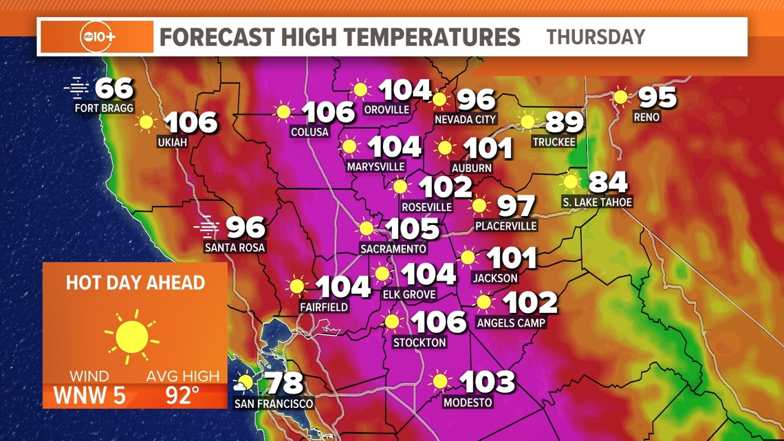
CALIFORNIA, USA — A second day of high temperatures above 100 degrees begins with warm morning lows in the 60s and 70s.
Thursday, we will see most valley locations in Northern California, with highs near 105 degrees. This is well above the average in the low 90s but not record-breaking. Sacramento has a record high on this date of 113 degrees and we will not be close to that number.
Most valley locations will be under a Heat Advisory through Friday with highs again near 103-105. There will be an evening breeze for the next two nights which will help cool the region.

Late summer heat has some benefits compared to the heat waves earlier in the year. With a lower sun angle, and less daylight you spend less time in direct searing heat, but precautions still need to be made to stay safe.
It's always difficult to predict the "last" heat wave but statistics show the typical last 100-degree day for the region is close to September 15. We have had 100-degree days into October, but to get three 100+-degree days this late in the summer is statistically very low.

There is a term called "Meteorological Summer" which refers to June, July and August. It is used to keep records from year to year that are consistent. During that period we have set many records, and an extension of summer heat well into September can test the area.
As we move into the weekend the temperatures will fall back into the 90s. Next week we are expecting more cooling into the 80s and early signs of a deeper area of low pressure bringing clouds and a chance of light rain. Expect more updates in the days ahead.
Watch more on ABC10 | California Heat Wave: Triple-digit temperatures for the first week of September


