Northern California is set for some big swings in weather patterns with rain then warm temps on the way.
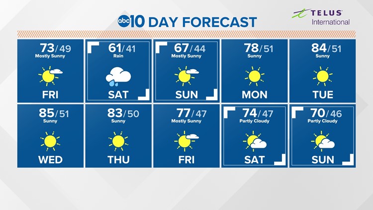
Friday will be mild and dry with highs in the 70s for the valley and 50s for Lake Tahoe.
Saturday the skies will change, the temperatures will drop to the 60s for highs in the valley and early in the day much welcome rain and snow moves in. This is not a very wet storm but it will last for most of Saturday with light valley showers and Sierra snow starting around 6,000 feet then dropping to 3,000 feet if there is anything left very early on Sunday.
Valley rain will total around 0.10-0.25 inches and the Sierra will see 3-6 feet of snow during the day on Saturday with likely chain controls.
► FORECAST DETAILS | Check out our hourly forecast and radar pages.
► GET WEATHER ALERTS TO YOUR PHONE | Download the ABC10 mobile app
► WEATHER IN YOUR EMAIL | Sign up for the Daily Blend Newsletter
Sunday will clear with temps in the 60s.
Beginning Monday warm temps move in that will surprise a lot of people. We will be near 80 on Monday and close to records.
From Tuesday to Thursday there should be very warm temperatures for this time in March will move in and spot could top the mid 80s. This will challenge daily temperature records and will affect many western states at the same time.
Heat-related issues may affect some very specific groups that are caught off-guard but it's more noteworthy how early these weather conditions are for the season.
► WEATHER IN-DEPTH: The latest Drought Monitor isn't bearing good news. Portions of the state has slipped deeper into more severe and extreme categories. It's not too surprising. ABC10's Chief Meteorologist Monica Woods dives explains it all and why a "Miracle March" at this point would likely causing a flooding event.


