SACRAMENTO, Calif. — The extremely hot and dangerous weather that we've been talking about all week is finally here.
Morning low temperatures are in the upper 60s across the valley, low 70s in the foothills. By midmorning, expect temps to climb into the 80s.
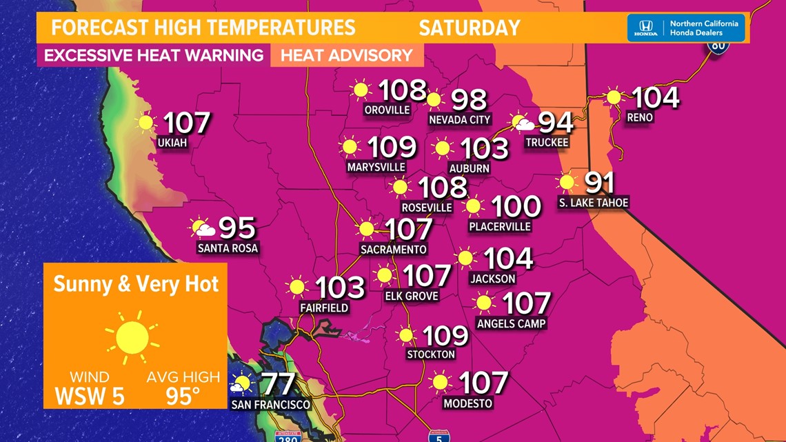
At 11 A.M., an Excessive Heat Warning goes into effect for areas below 4,500 feet, while a Heat Advisory goes into effect for areas above 4,500 feet.
By the late afternoon, temps around the valley will be between 105° and 110°. Even the Delta – which is normally spared the worst of the heat – will be pushing 105° today. Expect temperatures around the Sacramento metro of between 106°-109°. Stockton and the northern Sacramento Valley will climb towards 109°. Modesto will be around 107°.
The foothills will be around 100° this afternoon, while Sierra locations will see temperatures climb to between 90°-95°. Many folks in these communities have limited or no air conditioning, which makes these temps even more dangerous.

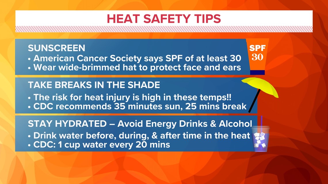
If you are impacted by this heat and need somewhere to go, ABC10 has compiled a list of cooling centers around our region. Click here to find a cooling center near you, or view the statewide list from CalOES. HeatReadyCA.com has helpful tips and tools to keep you and your family safe during this heatwave.

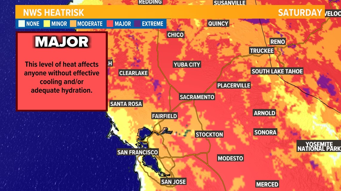
If you have any outdoor plans this afternoon or early evening, consider postponing them until around sunset or canceling them altogether. This heat is very dangerous. Major Heat Risk will be present across the region today, which means anyone who is not drinking plenty of water and taking frequent breaks in the shade (about every 20-30 minutes), heat-related illnesses are very possible.

Part of what will make the heat so dangerous is that there will be almost no overnight relief. The overhead high pressure is stamping out the Delta Breeze and coastal influence in general. Only areas along the immediate Pacific Coast will be fortunate enough to have that marine influence to keep them cool.
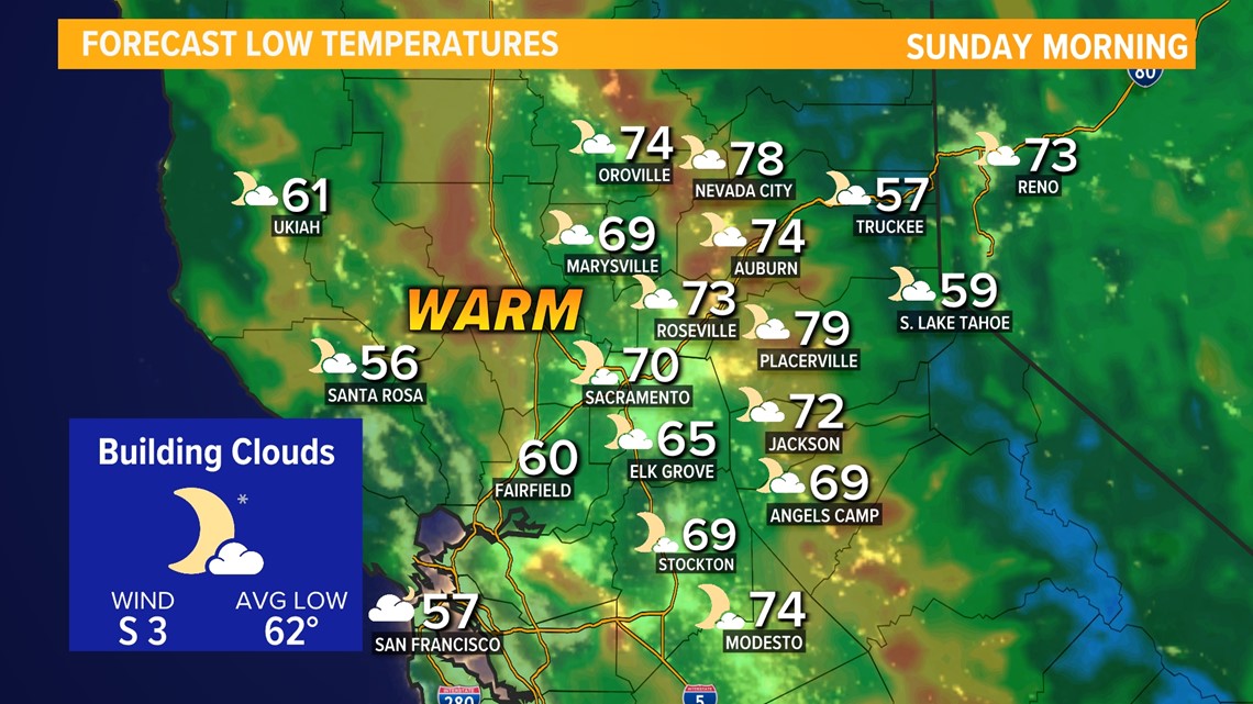
This means that valley low temperatures tomorrow morning will be around 70°, with only more rural areas remaining in the mid-60s. Foothill communities will be in the mid to upper 70s tomorrow evening, with some places likely staying in the low 80s!
Another wrinkle to contend with is the clouds, which will be building in overnight. Heat usually radiates out to space on a clear and windless night, allowing for more cooling. Clouds act as a blanket and help to keep us warmer by reflecting that heat back towards the ground.

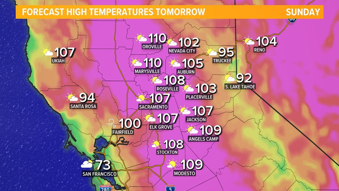
Sunday will be another very hot day with similar afternoon highs in the valley. However, since we'll be starting off warmer than we did on Saturday, it's likely that many Sierra and foothill locations will be warmer on Sunday by a 2-4 degrees than on Saturday.
The Delta Breeze is likely to try to get going again Sunday evening, which will provide some late-day relief for the valley and other Delta-influenced areas.

If we see some lingering cloud cover during the daytime on Sunday, it is possible highs come down a few degrees on Sunday, though right now it's not expected that cloud cover will have a noticeable impact on daytime highs. Mostly sunny skies are expected tomorrow.
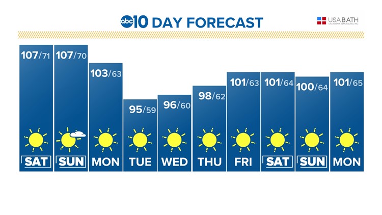
Finally, some noticeable relief on Monday as the high pressure no longer sits directly overhead. Temps will still be in the triple digits for many, but closer to 100° than 110°.
As the high-pressure scoots east Monday, it may drag some monsoon moisture with it, allowing for a thunderstorm or two to pop up in the Sierra.
HERE'S A BREAKDOWN OF THE NEXT WEEK
SUNDAY: Excessive Heat Warning. Mostly sunny with near record highs from 108-111°. Lake Tahoe highs in the low to mid-90s. Heat Advisory for the Sierra above 4,500 ft.
MONDAY: Sunny with highs in the triple digits. Lake Tahoe highs in the upper 80s with a slight chance of an afternoon thunderstorm.
TUESDAY: Sunny with highs in the mid-90s. Lake Tahoe highs in the mid-80s.
WEDNESDAY: Sunny with highs in the low 90s. Lake Tahoe highs in the low 80s.
THURSDAY: Sunny with highs in the upper 90s. Lake Tahoe highs in the mid 80s.
FRIDAY: Sunny with highs in the low 100s. Lake Tahoe highs in the upper 80s.
SATURDAY: Sunny with highs near 100°. Lake Tahoe highs in the upper 80s.
SUNDAY: Sunny with highs near 100°. Lake Tahoe highs in the upper 80s.
WEATHER RESOURCES:
► FORECAST DETAILS | Check out our hourly forecast and radar pages.
► GET WEATHER ALERTS TO YOUR PHONE | Download the ABC10 mobile app
► WEATHER IN YOUR EMAIL | Sign up for the ABC10 Today newsletter
WATCH MORE: Here are ways to make sure your air conditioner is ready to take on the heat.