SACRAMENTO, Calif. — Widespread heat returns to Northern California this weekend following a cool start to May.
The Western United States, including Northern California, will bake under a nearly record strength high pressure system. The high pressure will be centered over the Pacific Northwest and British Columbia, where temperatures could soar as high as 20-30 degrees above average. Both Portland and Seattle will reach into the 90s.
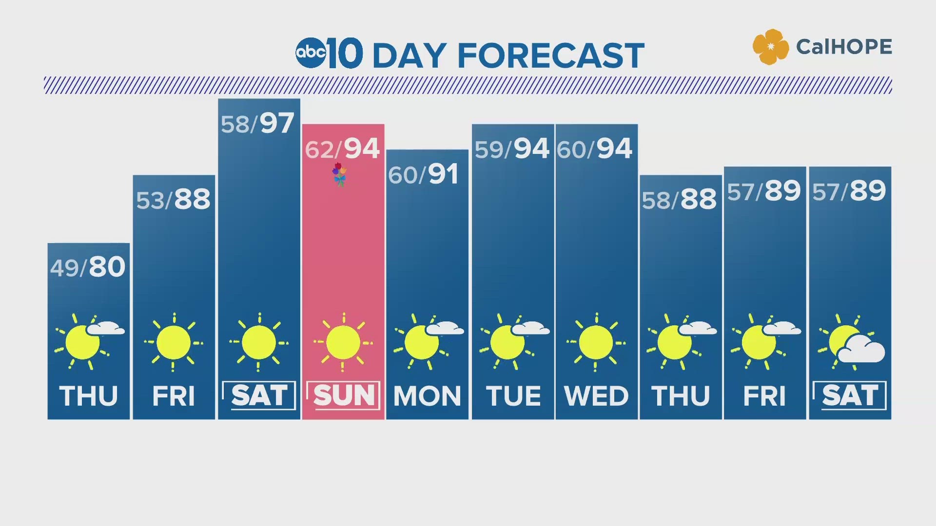
In Northern California, widespread 90s are expected by the weekend, and a few locations could flirt with triple digits for the first time this year. Areas north of Sacramento between Marysville and Redding have the best chances to reach 100 on Saturday when temperatures peak.
While it will still be very hot, especially considering the cool start to the month, heat on this scale isn't all too uncommon in May. The average in downtown Sacramento is around 80 for this time of year, but recent history has shown 100 degree days are fairly common in May. Since 2016, May of every year has experienced 100 degree days apart from 2018 and 2019.
For perspective on how the warming climate is altering the climate, downtown Sacramento only had six 100 degree May days in total before 1950 (dating back to 1878).
This week has featured a warming trend that will ramp up once the high pressure builds in on Thursday. High temperatures across the region will be in the upper 70s in the valley, 60s in the foothills and 50s in the Sierra.
Friday is when the building heat will become more noticeable. The forecast high is 88 in Sacramento and by Saturday temperatures will be in the mid to upper 90s.
"Highs are forecast to climb into the lower 90s across the Sacramento Valley on Friday, with 90s expected throughout the Central Valley on Saturday leading to widespread moderate heat risk," said NWS Sacramento in their Thursday morning forecast discussion. "Those without effective cooling and/or adequate hydration should reduce time in the sun during the warmest part of the day, stay hydrated, and stay in a cool place during the heat of the day."
A feature known as a cut-off low will slide under the high pressure to the north by Sunday, settling over California. This weak low pressure system won't do much to moderate temperatures, with low to mid 90s expected, but will force moisture into the region. Precipitable water values, a measure of how much moisture is in the atmosphere, will be elevated throughout the next 10 days. The moisture will likely manifest itself into afternoon shower and thunderstorm chances in the Sierra (mainly Southern and Central) but the valley will remain dry throughout the weekend and next week.
Long range forecast models have high pressure and warm temperatures sticking around for at least the next two weeks. 90s appear likely through this weekend and at least the first half of next week.
Waterways remain very cold as the record snow melt continues to make its way into local rivers and streams so practice extreme caution if you're headed for a swim.
WATCH ALSO:


