
SACRAMENTO, Calif —
The major storm that dropped up to 11 feet in parts of the Sierra is now mainly gone, finally giving Californians a chance to dig out.
The 6-11 feet that fell across the Sierra provided an extreme boost to the snowpack following the slow start the winter. On January 1, the statewide snowpack was at 28% but now it is at 104% and the April 1 average, the date at which the snowpack typically peaks, is at 95%. The recent storm all but assured another drought-free summer for Northern California.
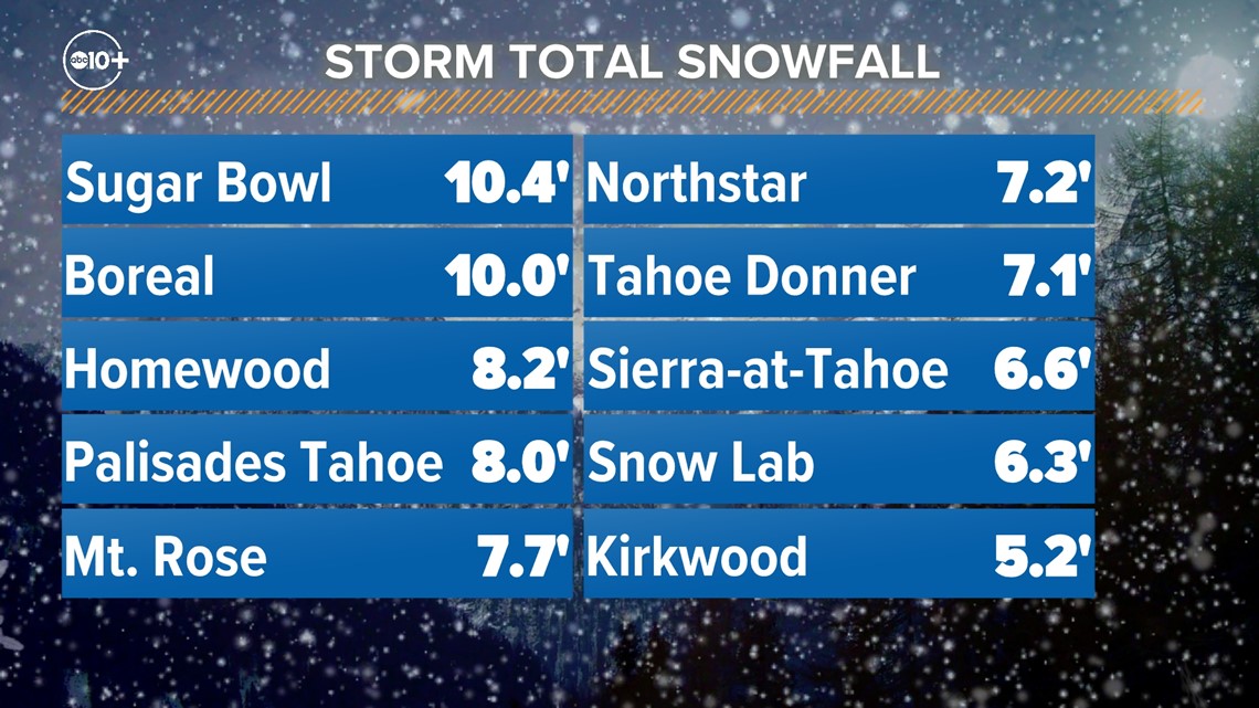
A few more inches of snow fell Monday in the central and southern Sierra. The Central Sierra Snow Lab received only 2.8” Monday, pushing the storm total at the lab to 78”. Sugar Bowl didn’t receive any measurable snowfall Monday but still led the Sierra in total snowfall with 127”.

Monday also saw the reopening of Interstate 80 following multiple days of it being shut down due to blizzard conditions. The issuance of a blizzard warning prior to the event was only the 8th such issuance since 2008 for the Sacramento National Weather Service office.
This storm was far more impactful for the Sierra and foothills compared to valley locations. The orientation of a strong, stalled-out trough of low pressure delivered strong onshore flow into the region and a process known as orographic uplift helped boost snow totals. Orographic uplift occurs when air is forced to rise over mountainous terrain, increasing precipitation amounts.
These effects were most prominent Friday and Saturday across the Sierra, producing heavy snowfall rates and whiteout conditions due to strong winds. At the same time, the valley was seeing periods of moderate to heavy rain showers.
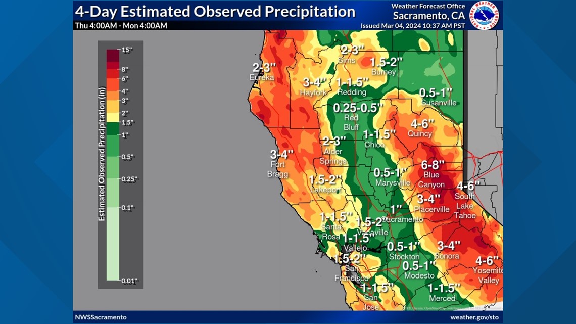
Most valley locations received 0.5-1.5" while the foothills below the snow line picked up 1.5-4".

Cool, cloudy conditions remain in Northern California Tuesday thanks to a weak system that continues to deliver light snow to the northern Sierra. A winter weather advisory is in place for portions of Plumas, Lassen and Shasta counties and portions of the coastal range thanks to an additional 2-4" of snowfall above 4,000 feet through Tuesday evening.
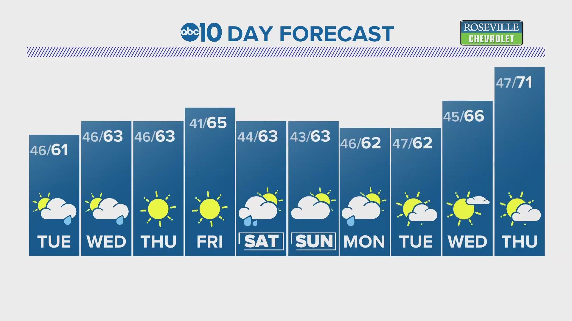
A few showers are possible Tuesday in the Sacramento area but not enough to affect outdoor events. Low 60s are forecast for the valley under mostly cloudy skies.
Wednesday will be a few degrees warmer than Tuesday as a ridge of high pressure forces its way into the region. The presence of high pressure overhead will mean dry conditions and a warming trend heading into the weekend. Partly to mostly cloudy skies Wednesday will give way to mostly sunny skies Thursday and Friday, the first sunny days in a while for Northern California.
Highs will be in the mid 60s through the rest of the work week with Friday being the warmest day of the week before temperatures drop back into the low 60s for the weekend.
WATCH ALSO: Snow update and more snow on the way


