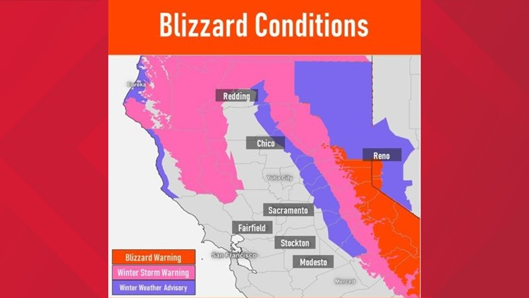
PLACER COUNTY, Calif. — A Sierra Blizzard Warning is expected to last until through Sunday, until midnight.
The National Weather Service originally announced the Blizzard Warning would go through early Sunday, however it was recently extended for elevations over 6,500 feet.
For areas above 3,000 feet, a Winter Storm Warning is in effect, with another one to two feet of snow expected above 4,000 in elevation, according to the National Weather Service. The warning runs until 4 a.m. Wednesday.
More snow is expected Monday and Tuesday, between two to four feet above 4,000 feet, according to the National Weather Service.
RELATED:
In-Depth Forecast
Scattered showers will continue in the valley on Sunday while periods of moderate to heavy snow continue in the Sierra as the most impactful storm of the winter continues.
Interstate 80 remains closed with no estimated time of reopening due to blizzard conditions. Highway 50 is open, but under chain controls, and travel remains very discouraged across the Sierra due to dangerous road conditions.
The expiration of the blizzard warning at midnight on Sunday does not mean the end of the rain and snow for Northern California.
Another system will push into the region on Monday, prompting the issuance of a winter storm warning in the areas where the blizzard warning has been the last three days.
The blizzard has produced very impressive snow totals since Thursday. 5-8 feet has fallen above 5,000 feet and light snow has fallen as low as 2,000 feet.
The heaviest snowfall with this next influx of moisture will be along and north of Interstate 80. Models aren’t in agreement in how much snow will fall on Monday and Tuesday but an additional 4-12" is possible north of Highway 50 by Wednesday, including the ongoing snowfall on Sunday. Some locations may get closer to 2 feet when it's all said and done.
Snow levels will steadily rise to around 3,000 feet by Monday evening and will be around 4,000 feet as the wet weather finally vacates the region.
Another 0.1-0.25" of rainfall is expected through Tuesday in the valley. Rain totals have been light in relation to the massive snow totals with generally 0.75-1.5" of rain falling in the valley since Thursday. 1.5-4" have fallen in the foothills below the snow line.
By Wednesday, most of interior Northern California will be dry as the system pushes south. Thursday and Friday will be dry before more wet weather returns by Saturday. Next weekend's storm system will be on the lighter side but is too far away to forecast exact totals.
High temperatures this week will remain below average but will warm up into the low to mid-60s by the end of the work week. The average high temperature in Sacramento this time of year is 65 degrees and highs will be near to slightly below that in the valley by Friday. Below-average temperatures return next weekend.
WATCH ALSO: