CALIFORNIA, USA — This forecast will change with new information, please check back for updates.
Tracking Hurricane Hilary | 9 a.m. Update
The latest forecast models show Major Hurricane Hilary with a minimal central pressure of 939 millibars Friday. Sustained winds are now 145 mph, just 10 mph away from becoming a Category 5 hurricane. Its current movement is northwest at 10 mph.
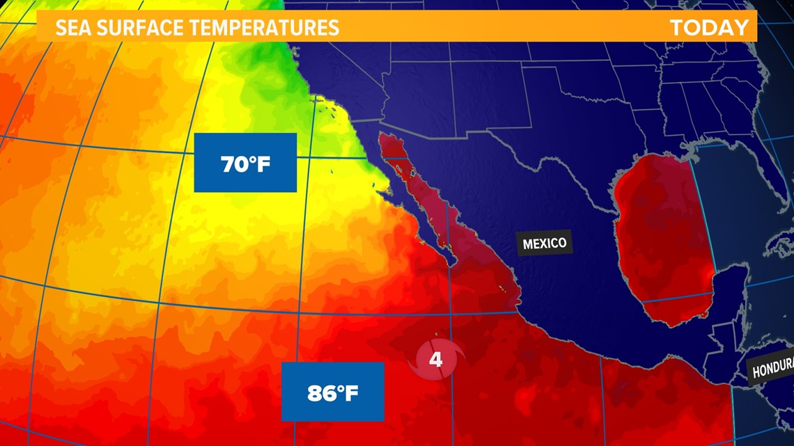
Hillary is currently churning in very warm Pacific waters. The current sea surface temperature in the vicinity of the storm is 86°F, and hurricanes need sea surface temps of at least 80° to sustain themselves. Hilary will remain in these hot waters for about another 12 to 24 hours before moving into significantly cooler waters. By Saturday morning, significant weakening is expected to begin.

During its approach into Southern California, the storm is expected to continue to weaken, dropping to tropical storm strength with 60 mph sustained winds by the time it reaches San Diego. This would be the first tropical storm to impact Southern California since an unnamed tropical storm hit the San Diego area in September 1939. Regardless of classification, it is very important to take this storm seriously. Rain and wind will begin to impact Southern California on Saturday.
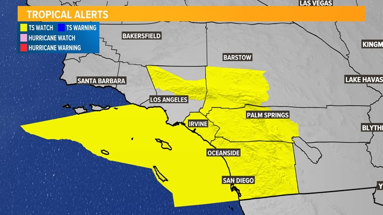
The National Hurricane Center in Miami has issued the first-ever Tropical Storm Watch for Southern California. This includes locations such as San Diego, Oceanside, Temecula, Anaheim, Palm Springs, Indio, and San Bernardino.

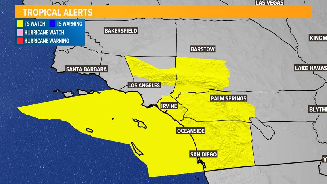
Southern California impacts will include strong, tropical-storm-force winds of 60 mph; heavy rain; and flash flooding. Especially for mountains and deserts, the risk of flash flooding is high. A High Risk for flash flooding has been posted for the east side of the SoCal mountains for the first time ever.
As the storm tracks north through California, rain and very humid conditions will follow. The Central Valley north of Bakersfield has a good chance of seeing some rainfall from the remnants of Hilary as the storm moves north. In and around Sacramento, that chance is about 50% as of Friday morning. Much better chance of rain for the Sierra and certainly the eastern slope of the Sierra in Nevada.

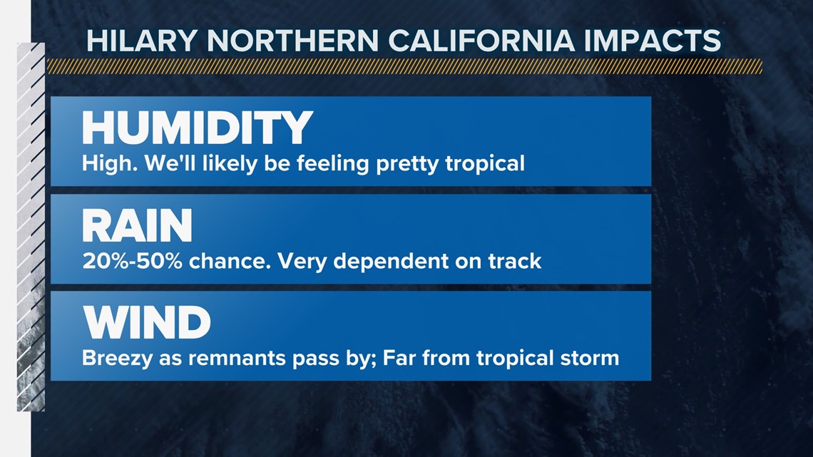
Winds in Northern California will not be nearly as strong as what Southern California will see. The storm will be significantly weaker by the time it moves into Northern California as the remnants of Hilary will have traversed multiple mountain ranges, rapidly weakening the storm. However, breezy conditions are still expected, with the potential for sustained 30 mph winds in the valley.
Northern California rainfall totals are uncertain and highly dependent on the track of the storm. A more westerly track means more rain, easterly means less rain. As of Friday morning, most of the valley is likely to see anywhere from a tenth of an inch to three-tenths of an inch of rain by the end of Tuesday.
What happened on Aug. 17 with Hurricane Hilary
Notably, Hurricane Hilary managed to pick up in wind speed and become a category 3 hurricane late in the evening.
Other key headlines from Thursday included:
- It moved from tropical storm to hurricane early Thursday
- Hurricane was upgraded to category 3 later in the evening with further strengthening expected
- First watches and warnings were issued for Mexico and the Gulf of California