
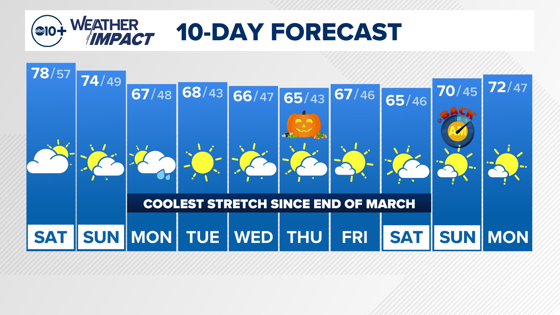
SACRAMENTO, Calif. — The period of quiet and seasonal weather is wrapping up for Northern California. An incoming system will bring us the coolest stretch of weather since the end of March along with a chance for showers and even flurries at the high passes.
When
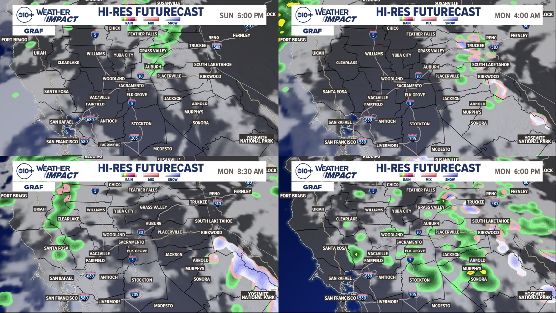
Sunday morning sees a cold front enter Northern California. The North Coast and Coastal Range will be the first areas to receive rain. By lunchtime to mid-afternoon, the front will arrive in the valley, keeping temperatures in the low to mid-70s on Sunday, and bringing a slim chance for rain to the valley floor. Right now, rain chances are not higher than about 25%.
By late afternoon Sunday, the cold front and associated showers arrive in the Sierra. This is where the majority of the impacts will be, with rain chances mainly north of US-50, and a dusting of snow possible along the highest passes of I-80 and US-50.
Gusty winds will pick up Sunday with the cold front passing through. Valley gusts could be up to about 20 mph with gusts in the Sierra of 35-45 mph.

The best chance for a dusting of snow is going to be Sunday night into Monday, then again Monday evening into Tuesday morning. Snow totals on the passes of I-80 and US-50 are very likely to be an inch or less, so travel shouldn't be extremely impacted but it will be slower going than usual. Icy spots on the main highways are also unlikely, but patches of ice on side roads Tuesday morning aren't out of the question.
Models are beginning to pick up on some light valley showers Monday afternoon/evening in the valley as the system exits the region.
► Stay up to date with the forecast and weather impact team with the ABC10+ streaming app. Here's how to download it for free.
Impact
A Weather Impact Alert for the Sierra from Sunday afternoon to Tuesday morning.

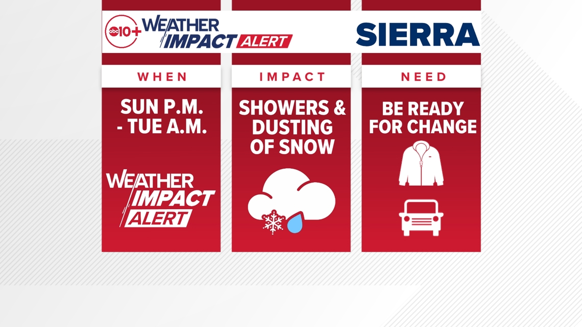
In the Sierra, gusty winds could cause difficult driving conditions as well as blow around loose objects. Overall, Sierra rainfall totals will be on the lighter side. Areas that see the highest totals are likely to be north of I-80, with up to about a half-inch of rain expected.
Monday morning and Monday night/Tuesday morning, there is potential for some flurries and light snow above 6,500 ft. that could stick to the high passes. It's unlikely that truly disruptive winter weather will develop, but certainly an inch of snow or less is quite possible. Be prepared for slower travel across the high passes. High temps on Monday will likely be in the 30s and 40s.
In the valley, few impacts — if any — will be present to start the workweek. Rainfall totals will be less than a tenth of an inch across the valley, with many areas only seeing a hundredth of an inch or less.
Regardless of whether or not the valley sees showers, much cooler temps will be present all week. Highs in the middle to upper 60s are expected from Monday through to the weekend!
Weather Impact Resources
► FORECAST DETAILS | Check out our hourly forecast and radar pages
► GET WEATHER ALERTS TO YOUR PHONE | Download the free ABC10 mobile app
► GO DEEPER | Stream in-depth weather forecasts and investigative reports with the free ABC10+ streaming app
► WEATHER IN YOUR EMAIL | Sign up for our daily newsletter
► MEET THE WEATHER IMPACT TEAM | Chief Meteorologist Monica Woods, Carley Gomez, Brenden Mincheff, Rob Carlmark
Need
Be ready for a significant pattern change, especially if you're in the Sierra. A period of cooler weather with showers and flurries is expected to start the week. Have your warmer jacket ready and give yourself some extra time driving on Monday and Tuesday morning.
In the valley, not much needs to be done. Just remember cooler temps in the 60s are expected during the afternoons so you'll need to dress a little warmer!
ABC10: Watch, Download, Read


For more ABC10 news and weather coverage on your time, stream ABC10+ on your TV for free:
► Roku - click here
► Amazon Fire - click here
► Apple TV - click here
GO DEEPER : The state had a historic winter and the ABC10 Weather impact Team is investigating where the water is going and if we're wasting it.