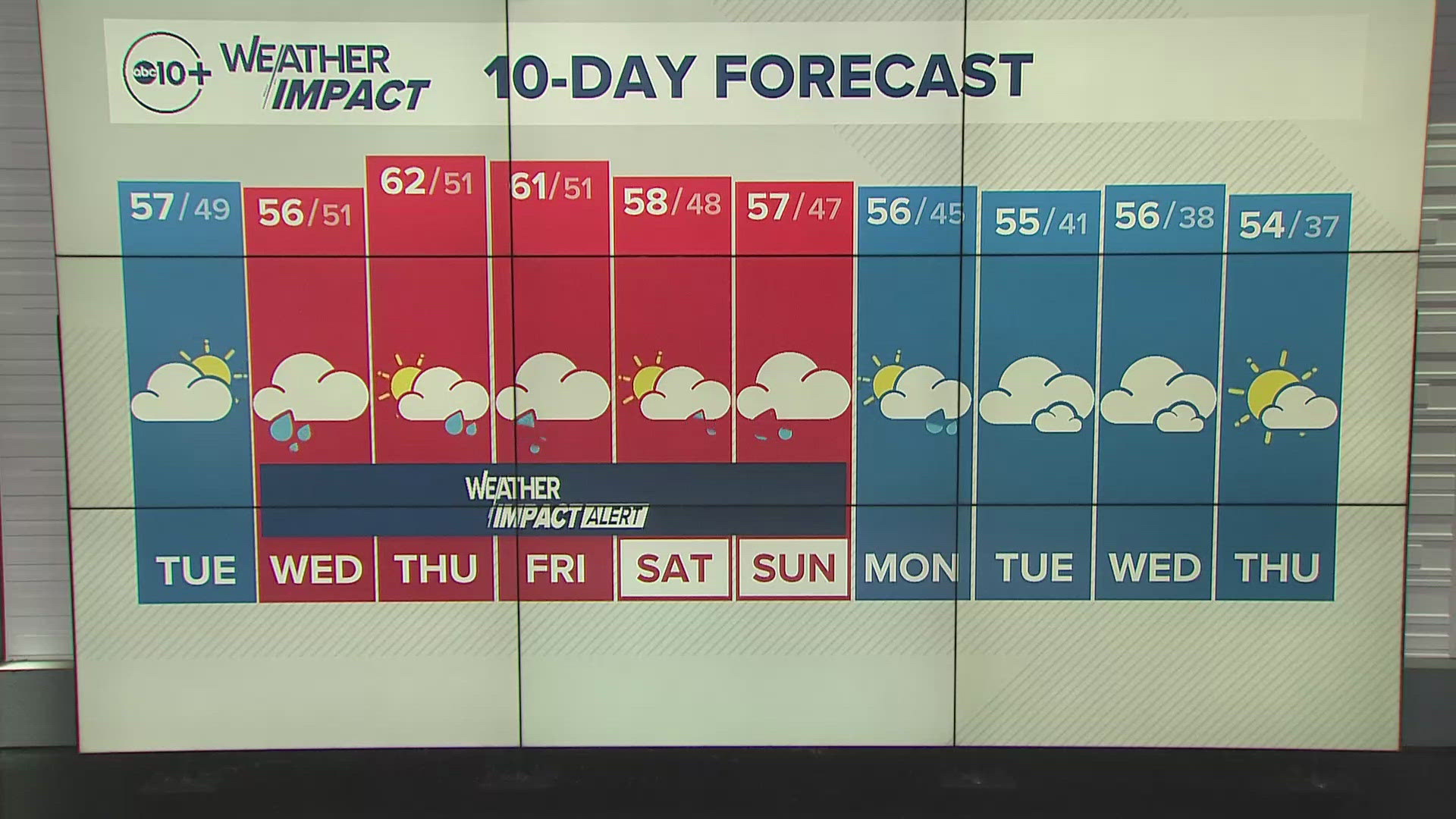
SACRAMENTO, Calif. — Weather conditions forecast for the Sacramento region will change pretty quickly during the day Wednesday with rain and snow moving in from a wet pattern and atmospheric river.
The storm cycle begins with a deep area of low pressure in the Pacific linking up with deep moisture from the subtropics. This will bring in heavier amounts of rain and snow but will change depending on the temperatures in the mountains.
There will be breaks in the rain and snow but they will be changing as the storm develops.
WHEN

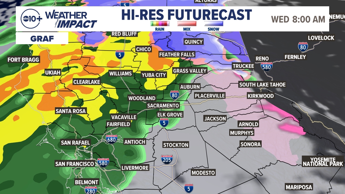
The beginning of the storm will impact far Northern California late Tuesday night with rain and snow. By early Wednesday morning, we will get a combination of rain and snow, with the snow level around 4,000-5,000 feet at the beginning of the day. This rises to about 7,000 feet by late Wednesday and even higher going into Thursday.

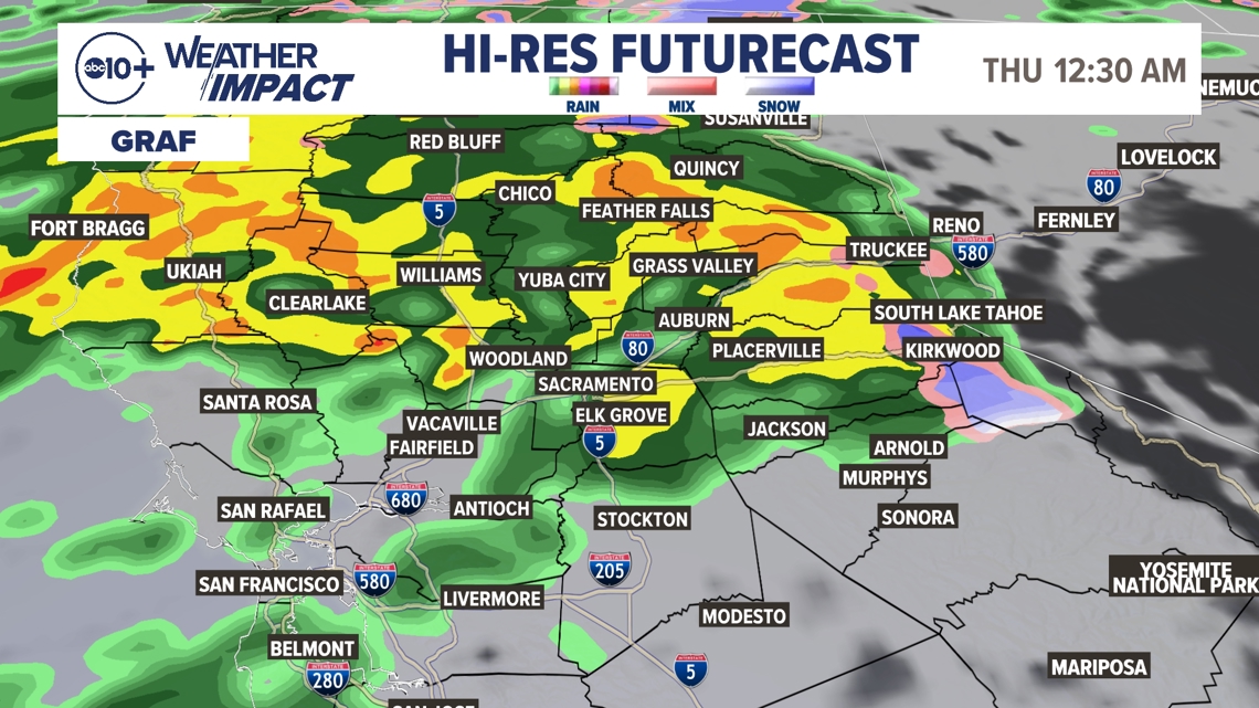
We will have on-and-off rain mostly Thursday and Friday then a colder system drops the snow level to about 5,000 feet Saturday to Sunday with clearing on Monday.
We will get more valley rain Saturday and Sunday, too.
► Stay up to date with the forecast and weather impact team with the ABC10+ streaming app. Here's how to download it for free.
IMPACT
The main impact will be extended periods of wet weather with only a few breaks. Expect wet roads and longer commutes. Expect some crashes on area roadways, as well as snow over the mountain passes mostly Wednesday and the weekend with heavy rain for the passes Thursday and Friday.
Since this is the middle of fall, there will be lots of leaf debris that could easily clog street drains and cause localized flooding. Wind will kick up as well during periods of heavy rain and that will create lower visibility as well as more debris.
Chain controls are possible early Wednesday as well as during the weekend. Plans should be made for safe travel during this period of very active weather.
Weather Impact Resources
► FORECAST DETAILS | Check out our hourly forecast and radar pages
► GET WEATHER ALERTS TO YOUR PHONE | Download the free ABC10 mobile app ► GO DEEPER | Stream in-depth weather forecasts and investigative reports with the free ABC10+ streaming app
► WEATHER IN YOUR EMAIL | Sign up for our daily newsletter
► MEET THE WEATHER IMPACT TEAM | Chief Meteorologist Monica Woods, Carley Gomez, Brenden Mincheff, Rob Carlmark
NEED
Since this is a dynamic system, constant updates will be made during the event. One of the challenging issues is where the rain totals will drop off to much lower amounts. As of Tuesday, this looks to be about the I-80 corridor with heavier rain north and lighter amounts south. We will see 2-4" of rain along this line with higher amounts in the higher elevations.
Periods of dry weather will be very important and monitoring the forecast will be important. As of Tuesday, the best windows of dry weather look to be all day Tuesday, Thursday late afternoon for the Valley, then again late in the day Saturday.

