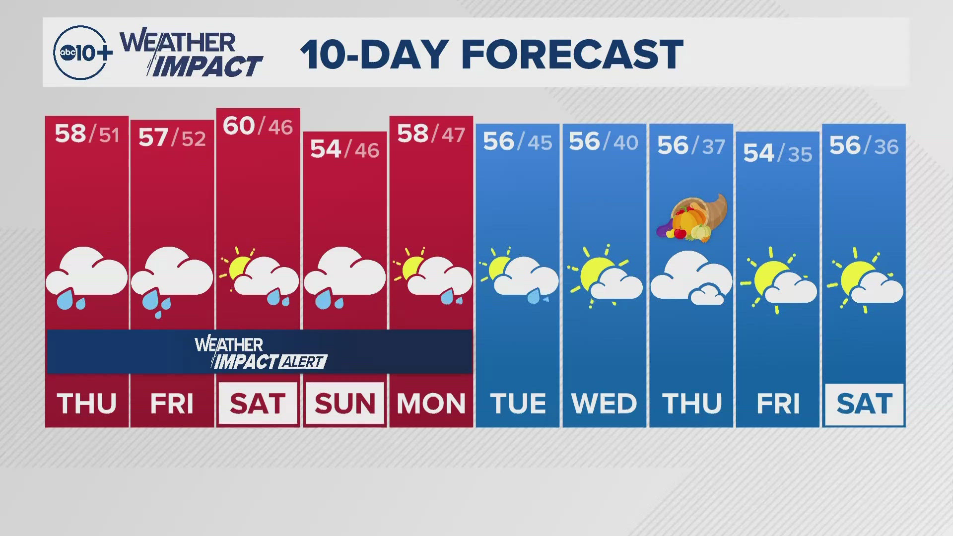
SACRAMENTO, Calif. — Weather conditions forecast for the Sacramento region will change pretty quickly during the day Thursday with rain and snow moving in from a wet pattern and atmospheric river, then moving to the north.
The storm cycle begins with a deep area of low pressure in the Pacific Ocean linking up with deep moisture from the subtropics. This will bring in heavier amounts of rain and snow but will change depending on the temperatures in the mountains.
There will be breaks in the rain and snow but they will be changing as the storm develops.
WHEN
The change of the path of heaviest rain moves to the north of Sacramento Thursday with some clearing for Stockton and Modesto from the morning to the afternoon. Even Sacramento could see only clouds later in the day, a break in the action before the storm comes back Friday.

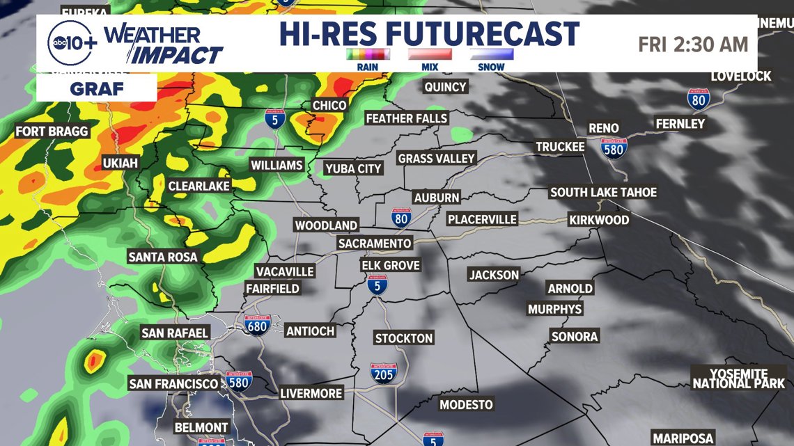
There is a sharp line of heavier rain vs. light rain and dry conditions once you get south of I-80. For example, Stockton and Modesto will get much less rain Thursday while Sacramento will get at least 0.50" or more between Wednesday into Thursday.

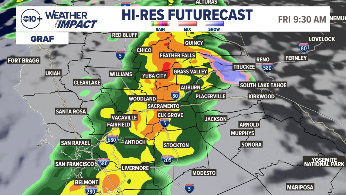
Watch for many changes Friday with heavier rain and snow coming back. Daytime on Friday will likely have one of the heaviest rain periods along with falling snow levels to the passes and below by Saturday.
We will get more valley rain Saturday and Sunday, with Monday showing more potential for rain and snow.
There is a Winter Weather Advisory Friday afternoon until Tuesday for winter conditions in the Sierra with wind and snow and lower visibility at times. Road impacts can be serious with heavy snow, slow driving and closures possible.
► Stay up to date with the forecast and weather impact team with the ABC10+ streaming app. Here's how to download it for free.
IMPACT
The main impact will be extended periods of wet weather with only a few breaks. Expect wet roads and longer commutes. Expect some crashes on area roadways, as well as snow over the mountain passes mostly for the weekend with heavy rain for the passes Thursday and part of Friday.
Since this is the middle of fall, there will be lots of leaf debris that could easily clog street drains and cause localized flooding. Wind will kick up as well during periods of heavy rain and that will create lower visibility as well as more debris.
Chain controls are possible during the weekend if not earlier it just depends on the timing of the cold air coming back. Plans should be made for safe travel during this period of very active weather.
Weather Impact Resources
► FORECAST DETAILS | Check out our hourly forecast and radar pages
► GET WEATHER ALERTS TO YOUR PHONE | Download the free ABC10 mobile app ► GO DEEPER | Stream in-depth weather forecasts and investigative reports with the free ABC10+ streaming app
► WEATHER IN YOUR EMAIL | Sign up for our daily newsletter
► MEET THE WEATHER IMPACT TEAM | Chief Meteorologist Monica Woods, Carley Gomez, Brenden Mincheff, Rob Carlmark
NEED
Since this is a dynamic system, constant updates will be made during the event. One of the challenging issues is where the rain totals will drop off to much lower amounts. As of Thursday, this looks to be about the I-80 corridor with heavier rain north and lighter amounts south. We will see 2-4" of rain along this line with higher amounts in the higher elevations.
Periods of dry weather will be very important and monitoring the forecast will be important. As of Thursday, the best windows of dry weather look to be Thursday late afternoon for the valley, then again late in the day Saturday.
ABC10: Watch, Download, Read
For more ABC10 news and weather coverage on your time, stream ABC10+ on your TV for free:
► Roku - click here
► Amazon Fire - click here
► Apple TV - click here
GO DEEPER: Tracking Fujiwara Effect and atmospheric rivers: Meteorologist Carley Gomez is following the atmospheric river bringing rain and snow into Northern California.

