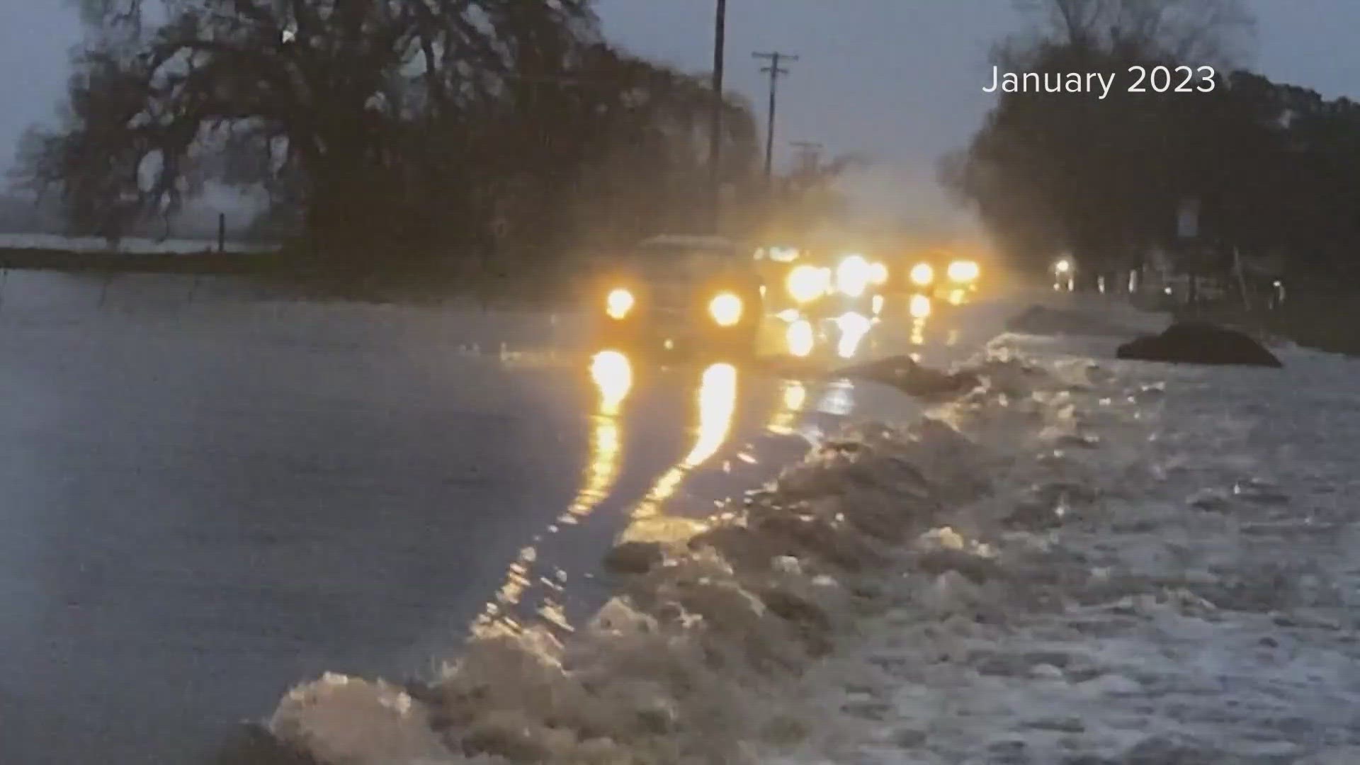
SACRAMENTO, California — A strong, potentially super El Niño is currently brewing in the Pacific and is expected to peak in December or January.
While there's much chatter about the upcoming El Niño winter and what it could mean for California, the answer might not be what you expect.
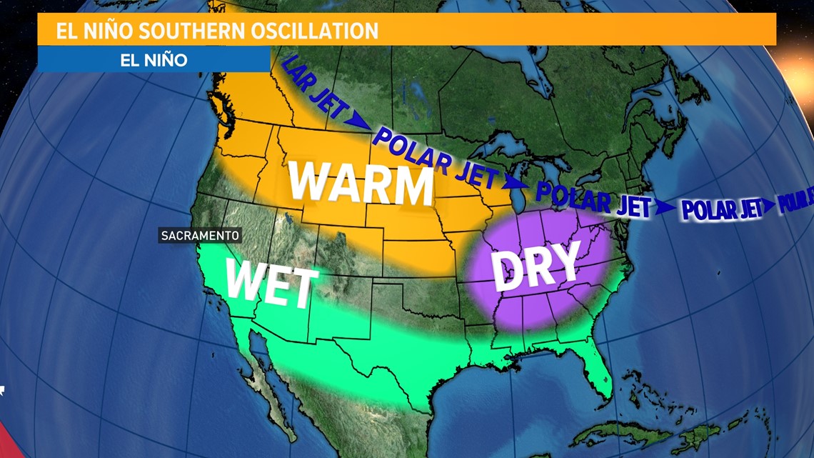
El Niño is one of the three phases of the El Niño Southern Oscillation (ENSO), with the other two being La Niña and the neutral phase. ENSO shifts back and forth irregularly every two to seven years, bringing predictable shifts in ocean surface temperature and disrupting the wind and rainfall patterns across the tropics, according to NOAA.
In California, El Niño is typically associated with wetter than normal conditions, especially the further south you go in the state.

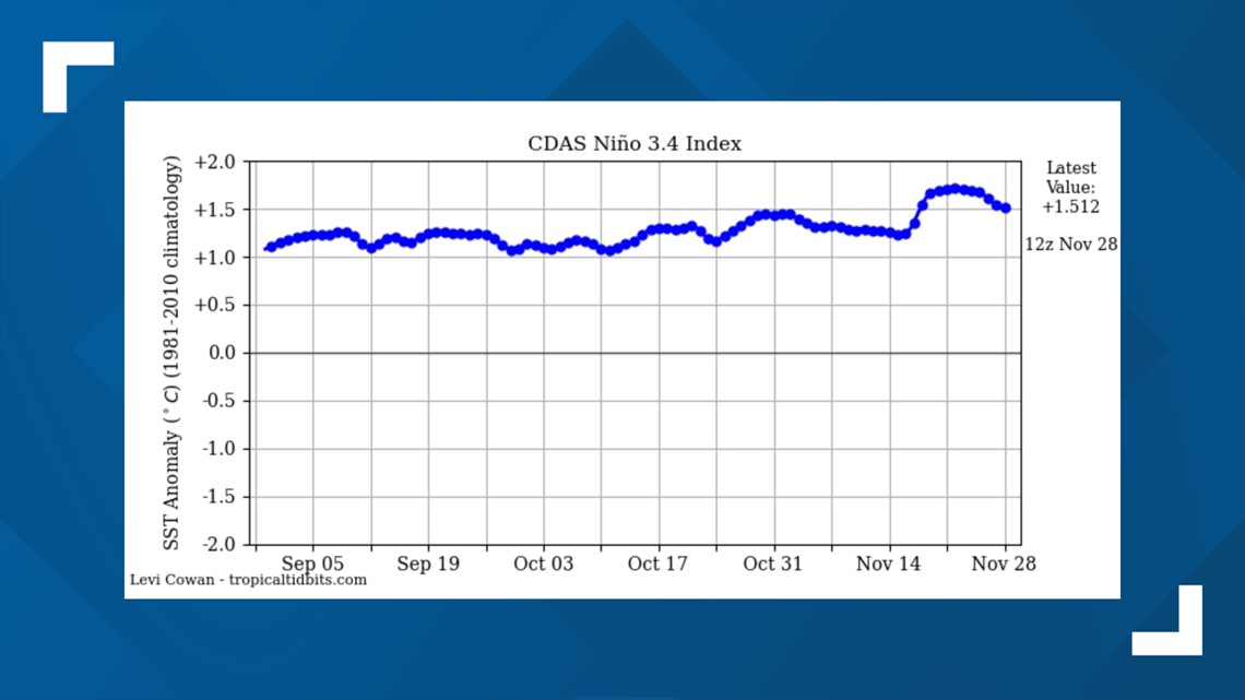
The latest update on the strength of El Niño from NOAA gives a greater than 55% chance of a strong El Niño persisting through the winter and a 35% chance of an event in strength rivaling the 2015/16 super El Niño winter.
El Niño strength is determined by the sea surface temperature of the central equatorial Pacific in the Niño 3.4 region.
"Events are defined as 5 consecutive months at or above the +0.5° anomaly for warm (El Niño) events and at or below the -0.5 anomaly for cold (La Niña) events,” wrote Jan Null, an Adjunct Professor of Meteorology at San Jose State, on his website ggweather.com.

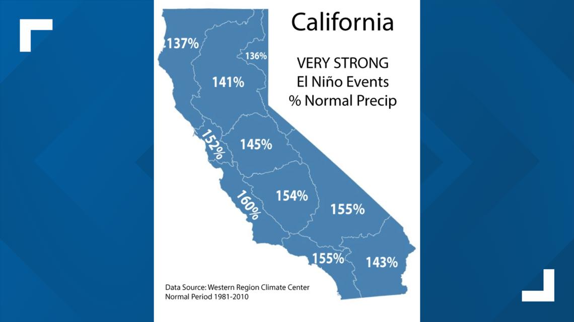
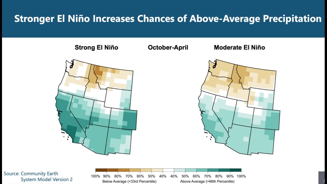
Precipitation data from El Niño events in California shows although wetter than average conditions are favored, it’s a bit of a mixed bag even for strong and super events.
There have been 26 El Niño winters since 1950. Here’s what the data says about various El Niño strengths and what they mean for California.
Super (very strong) El Niño
A super El Niño has only happened three times in recorded history. Sea surface temperatures in the equatorial Pacific must meet or exceed 2 degrees C above normal to reach the threshold of super El Niño.
Super El Niño years include 1982-83, 1997-98 and 2015-16.
The most recent case of a very strong El Niño was in the aforementioned winter of 2015/16. Precipitation patterns acted in a way resembling something closer to a typical La Niña winter, with Southern California being quite dry that winter and slightly above average precipitation for Northern California.
The other two events produced some of the wettest years in the history of California.

Strong El Niño
Strong El Niño years happen when sea surface temperature anomalies land between 1.5-1.9 degrees C above average. This has happened five times since 1950 in the following years:
- 1957-58
- 1965-66
- 1972-73
- 1987-88
- 1991-92
"Strong El Niño events have a pretty big effect historically on precipitation in California and the general southwestern United States. Moderate events do as well, but don't have as much of an effect," said Andy Hoell, a research meteorologist at the NOAA Physical Sciences Laboratory in Boulder, Colorado.
One caveat is only two of the five strong events produced wetter than normal conditions in Northern California, but those years were so wet they sway the data toward far wetter than average when the data is averaged.
Regardless, data from previous strong El Niño winters shows the driest winter for the Sacramento River basin was 73% of average.

Moderate El Niño
There have been seven moderate El Niño's since 1950, including the following years:
- 1951-52
- 1963-64
- 1968-69
- 1986-87
- 1994-95
- 2002-03
- 2009-10
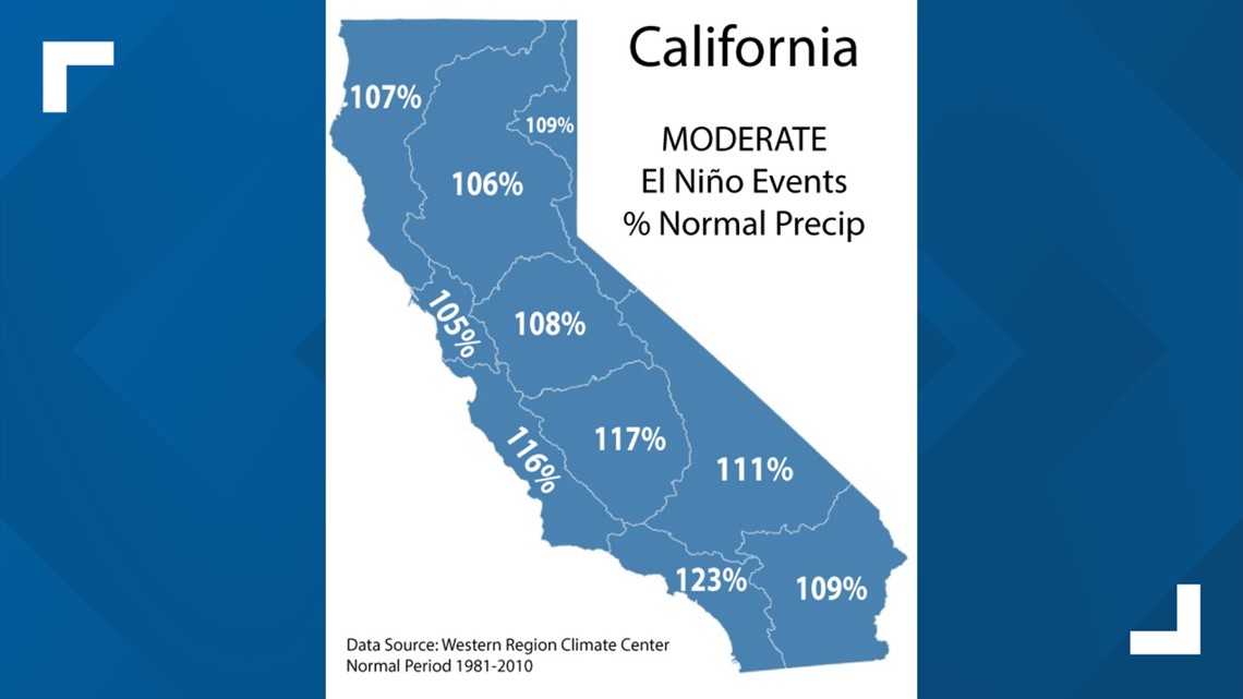
Moderate El Niño's fall between 1.0-1.4 degrees C above average and are correlated with wetter than normal conditions across the entirety of the state.
In Northern California, moderate events lean slightly above average while the signal towards wetter is stronger in Southern California.

Weak El Niño
There have been 11 weak El Niño's since 1950, including the following years:
- 1952-53
- 1953-54
- 1958-59
- 1969-70
- 1976-77
- 1977-78
- 1979-80
- 2004-05
- 2006-07
- 2014-15
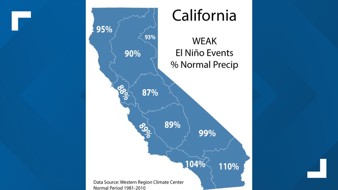
Sea surface temperatures in the equatorial Pacific must be between 0.5 - 0.9 degrees C to qualify as a weak El Niño.
Drier than normal conditions are favored for Northern California during weak events, although it is not unheard of to see extremely wet years in Southern California. The winters of 1977-78 and 2004-05 exceeded 200% of average across the southern tier of the state.

Based on how healthy reservoir levels are in California thanks to the record winter last year, Null said the prospect of a relatively dry winter shouldn’t keep Californians up at night.
“Here we are with reservoirs being in really good shape right now. A year of picking up only three quarters or 80% of normal would not be a big deal,” said Null.
Another typical feature of an El Niño winter in California is warmer storms due to storms being fed by the subtropical component of the jet stream rather than dropping down from the north.
“The fact you have that subtropical component to the jet, the storms are not as cold, you don't have these nice, cold, Gulf of Alaska lows dropping down as often during those years,” Null said.
That's been the case so far this year. The few storms that passed through California have been warmer and snowpack data reflects that.
In reality, the inherently chaotic atmosphere is impossible to forecast on a seasonal level, and when asked for a prediction about what he expected this winter, he joked, “ask me in April.”

