SACRAMENTO, Calif. — We had a certifiable scorcher Saturday as Downtown Sacramento made it to 108°! That's good enough to be the 3rd hottest day this year, behind only July 1st and July 2nd when we topped out at 109°. Our weather forecast shows that many Sacramento and San Joaquin Valley locations will once again be back there today.
First things first, lows this morning were in the upper 60s across the valley, though the real heat was in the foothills. Many areas did not make it below 80° this morning, which was about 2-5 degrees warmer than yesterday. That's important because that extra heat will carry over into this afternoon. Some clouds moved in overnight and are likely to be passing overhead throughout the daytime. This doesn't mean they'll help to moderate our afternoon temperatures, however.
An Excessive Heat Warning continues for areas below 4,500 feet, and a Heat Advisory remains in effect for areas above 4,500 feet through 11 P.M. tonight.

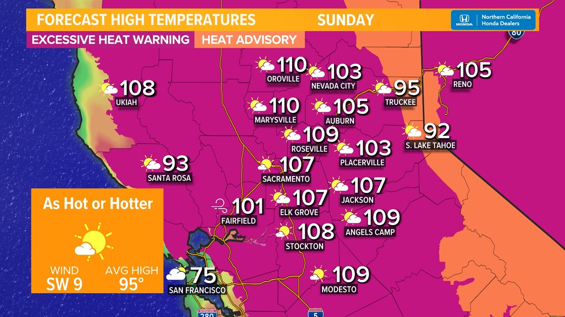
By the late afternoon, temps around the valley will once again be between 105° and 110°. Expect temperatures around the Sacramento metro of between 107°-110°. The northern Sacramento Valley will climb towards 110°. Stockton will be around 108°, Modesto will be around 109°.
Remember that extra 2-5 degrees of warmth this morning? That will help the foothills be that much warmer this afternoon compared to Saturday. Highs for areas like Auburn, Nevada City, and Placerville will be between 100° and 105°.
Sierra temperatures climb to between 90°-95° this afternoon. Many folks in these communities have limited or no air conditioning, which makes these temps even more dangerous.
If you are impacted by this heat and need somewhere to go, ABC10 has compiled a list of cooling centers around our region. Click here to find a cooling center near you, or view the statewide list from CalOES. HeatReadyCA.com has helpful tips and tools to keep you and your family safe during this heatwave.
If you have any outdoor plans this afternoon or early evening, consider postponing them until around sunset or canceling them altogether. This heat is very dangerous. Major Heat Risk will be present across the region today, which means for anyone who is not drinking plenty of water and taking frequent breaks in the shade (about every 20-30 minutes), heat-related illnesses are very possible.
WEATHER RESOURCES:
► FORECAST DETAILS | Check out our hourly forecast and radar pages.
► GET WEATHER ALERTS TO YOUR PHONE | Download the ABC10 mobile app
► WEATHER IN YOUR EMAIL | Sign up for the ABC10 Today newsletter

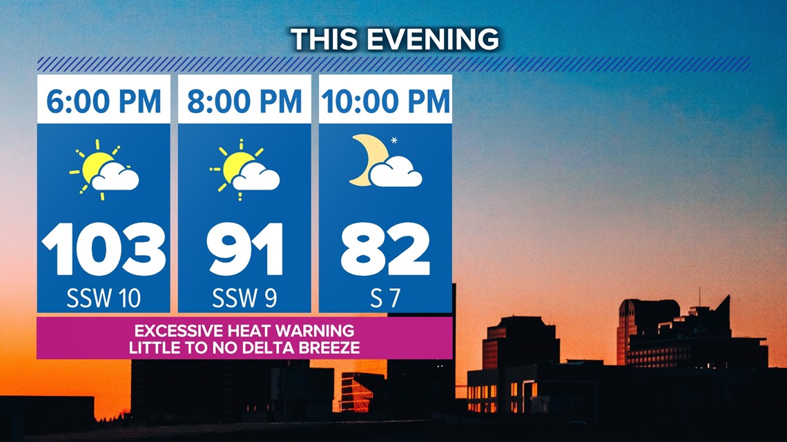
The Delta Breeze is likely to try to get going again Sunday evening, which might provide some late-day relief for Delta areas. However, I'm not expecting many places, including Sacramento, to feel much – if any – cooling effects this evening. We are going to stay warm through the evening hours, with temperatures still near 100° by 7 this evening and in the 90s through the 8 o'clock hour.
The Excessive Heat Warning and Heat Advisory are set to expire at 11 tonight.
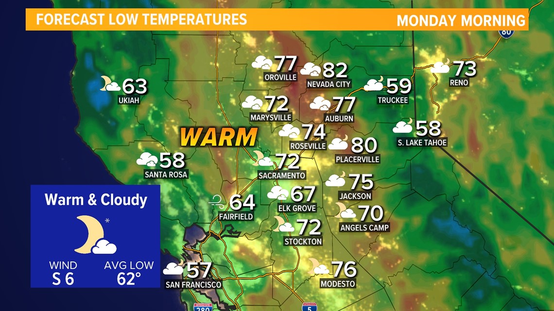
A warm overnight is once again in store, especially for foothill communities. Valley lows near 70°, while places like Jackson, Nevada City, and Placerville only cool towards the 80° mark.

Finally, some noticeable relief on Monday as the high pressure no longer sits directly overhead. Temps will still be in the triple digits for many, but closer to 100° than 110°. As the high-pressure scoots east Monday, it may drag some monsoon moisture with it, allowing for a thunderstorm or two to pop up in the Sierra.
Further cooling is in the forecast through midweek as temperatures drop back towards average in the middle 90s. However, the high pressure builds back westward as we near the end of the week. It's expected to set up over the intermountain west which would keep the worst of the heat away, but still send our highs back between 100°-103°.
BEAT THE HEAT: People are flocking to ice cream shops in just one of many attempts to cool down.