
SACRAMENTO, Calif. — The first of two storms to impact Northern California has arrived, and it will make for a soggy weekend.
Most of Saturday will see off-and-on rain in the valley. The scattered showers will be heavy but won't linger over one area too long.
That means that Saturday doesn't necessarily look like a total washout, although parks and other grassy areas will be wet and muddy. So, even though we'll see pauses in the rain, it's best to plan around it raining during the time you want to do things.

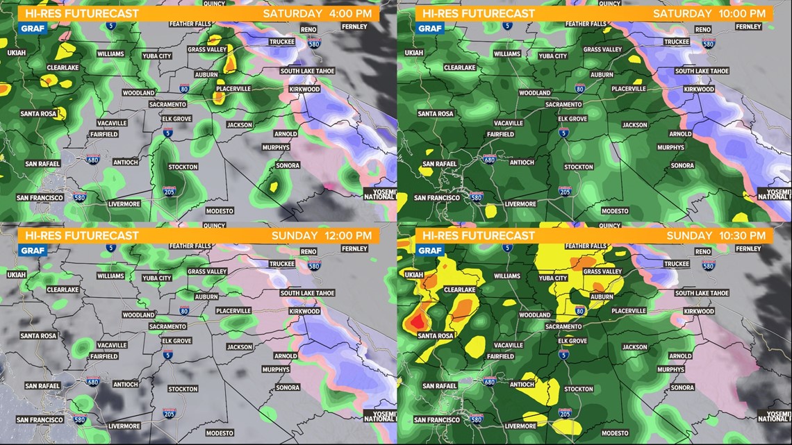
If there is a window of opportunity for clearing today, it's likely to be right around noon. It's about this time that showers look to be most scattered and it's a break before widespread showers arrive late in the afternoon into the evening.
Windy conditions are expected through Saturday afternoon. Valley wind gusts of 20-30 mph are expected, with stronger gusts in the Northern Sacramento Valley where a Wind Advisory is in effect for Saturday. Sierra gusts are expected to be up to 45 mph.
Overnight Saturday night into Sunday will see more widespread showers before a break looks likely around lunchtime Sunday.
Midday Sunday through the late afternoon may provide the best and driest period of the whole weekend to get things done without worrying too much about the rain. However, it's not the end of the storm.
Storm number two pushes in late Sunday and continues through Monday morning. This rain will be heavier, steadier and more widespread, and continue through the Monday morning commute.
The wind dies down through the first half of Sunday but picks up again Sunday into Monday during the second storm. Wind gusts during this time are looking similar, about 20-30 mph across the valley. Sierra gusts are expected to be around 45 mph.


A Flood Watch goes into effect for the valley on Sunday afternoon and continues through Monday.
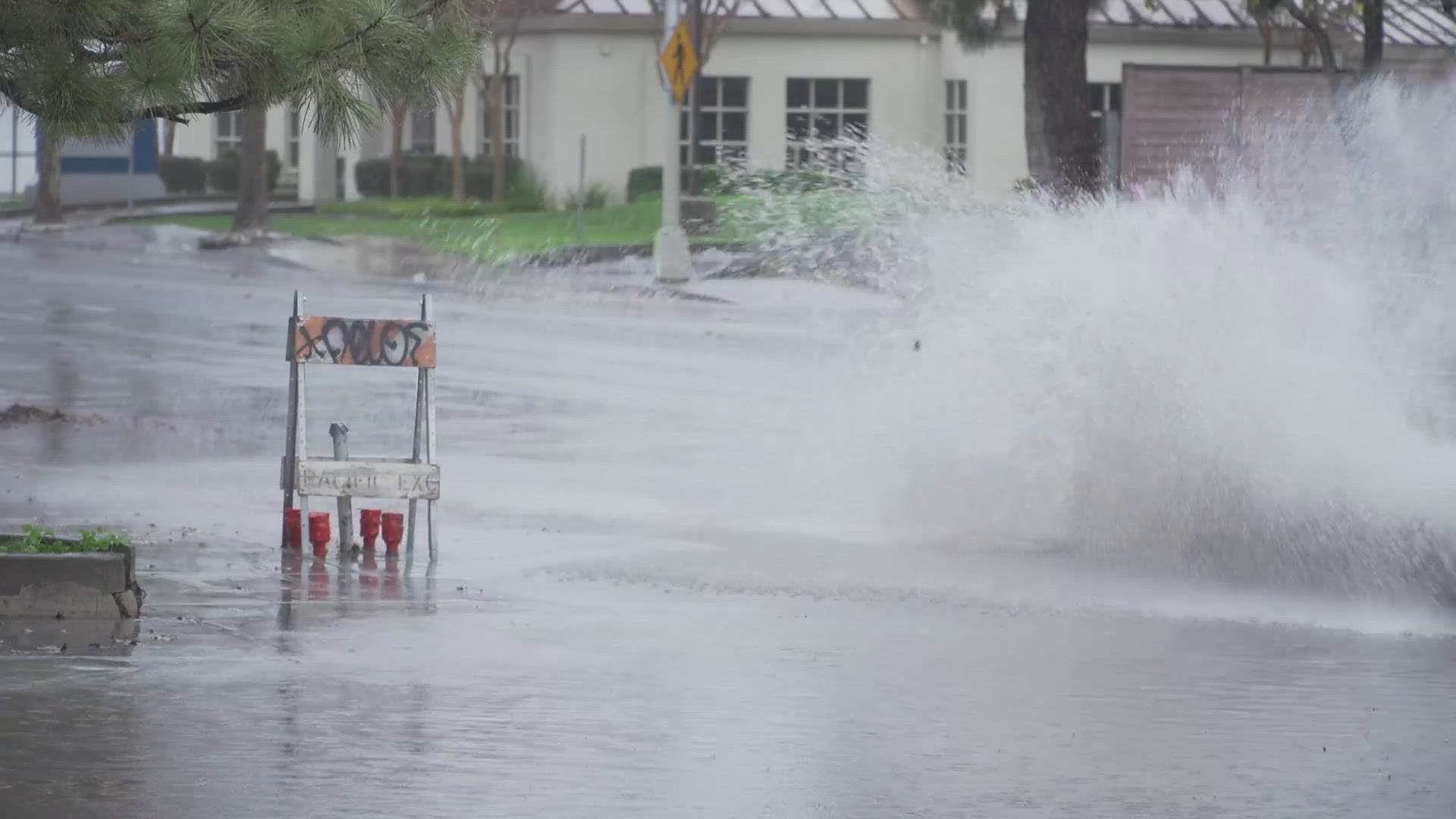
We're expecting to see heavy rain with about an inch of rain falling during this time. Minor roadway flooding is likely, especially on side streets and parking lots.
Be careful driving through standing water. In addition, smaller creeks and streams may overspill their banks. Areas prone to flooding should take precautions.
Large rivers like the Sacramento, American, San Joaquin, Tuolumne, Cosumnes, Yuba and Merced are not expected to flood, although the Sacramento River will be running high down the valley north of the city of Sacramento.
The Colusa and Tisdale weirs are expected to have water flowing through them into the Sutter Bypass.

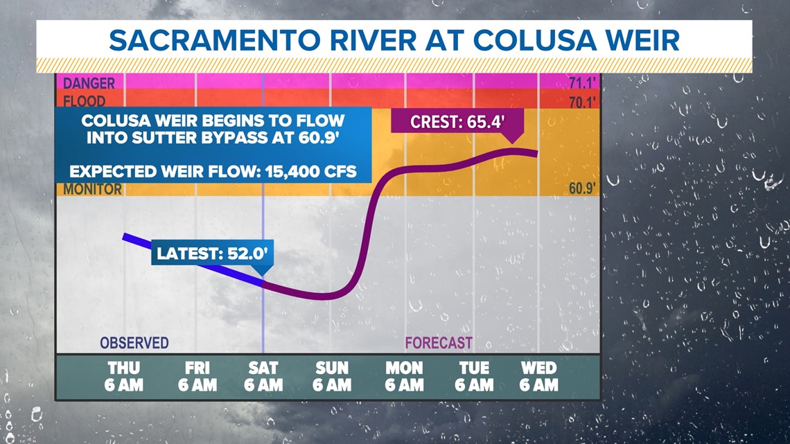
Major rivers will rise several feet through the duration of the storm, so be careful in and around water for the next several days.
For instance, the Sacramento River through downtown will rise five feet or more. Similar rises are expected along the Cosumnes and Merced rivers.
For the Sierra, a Winter Storm Warning is now in effect and continues until Monday evening. Be prepared for changing conditions in the Sierra each day with chain controls and other traffic control measures likely.
Saturday snow levels start out at about 7,000 feet on Saturday morning but will be lowering to 6,000 feet by the evening, perhaps even a bit lower.
Sunday through Monday snow levels are about 6,000 feet climbing to 7,000 feet. So, areas like Blue Canyon will likely miss out on the snow entirely, while areas at 6,000 feet will likely pick up a few inches, but then have it melt on Monday when the precipitation transitions back to rain.


For this reason, snow totals are a bit tricky. Areas below the passes will pick up a few inches then see it melt, then potentially get a little bit more right at the tail end of the storm.
So it'll be tough to stick a ruler in the ground because rainfall from the second storm will likely melt some of the accumulation from the first storm.
Rain totals by next Tuesday will come in between 1-2 inches in the valley. The foothills will see closer to 4-6 inches of rain.
The second storm winds down through the afternoon on Monday, concluding a 4-day long rainy stretch.
However, it's important to reiterate that rivers, creeks, and streams will be running higher and faster even after the rain stops. So just be careful around water all of next week.
Watch more from ABC10: California Storm: Little to no snow yet but more snow and heavy valley rain is on the way


