
CALIFORNIA, USA — Find the latest updates on Hurricane Hilary HERE.
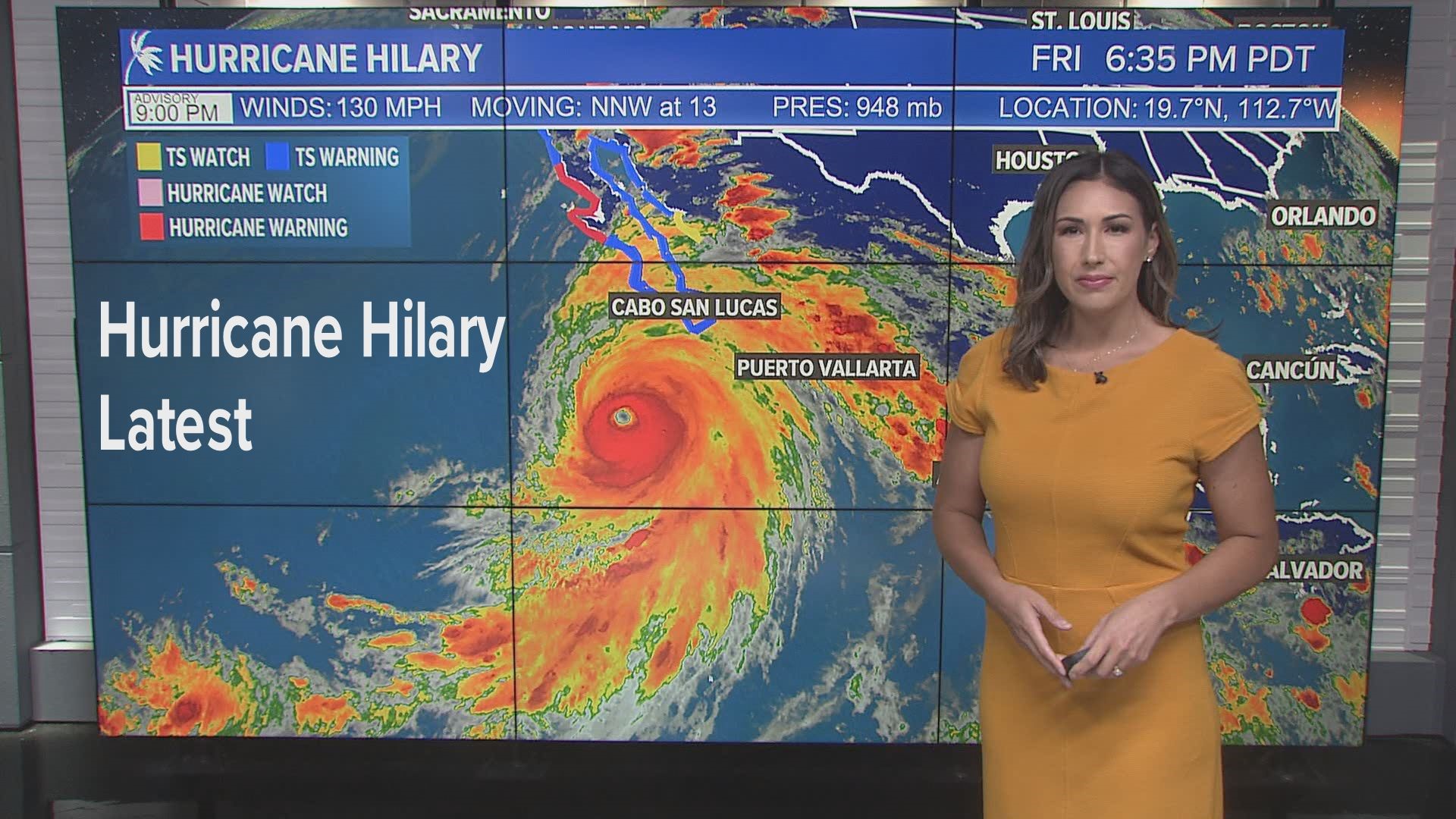
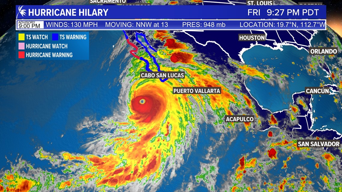
Tracking Hurricane Hilary | 9 p.m. Update
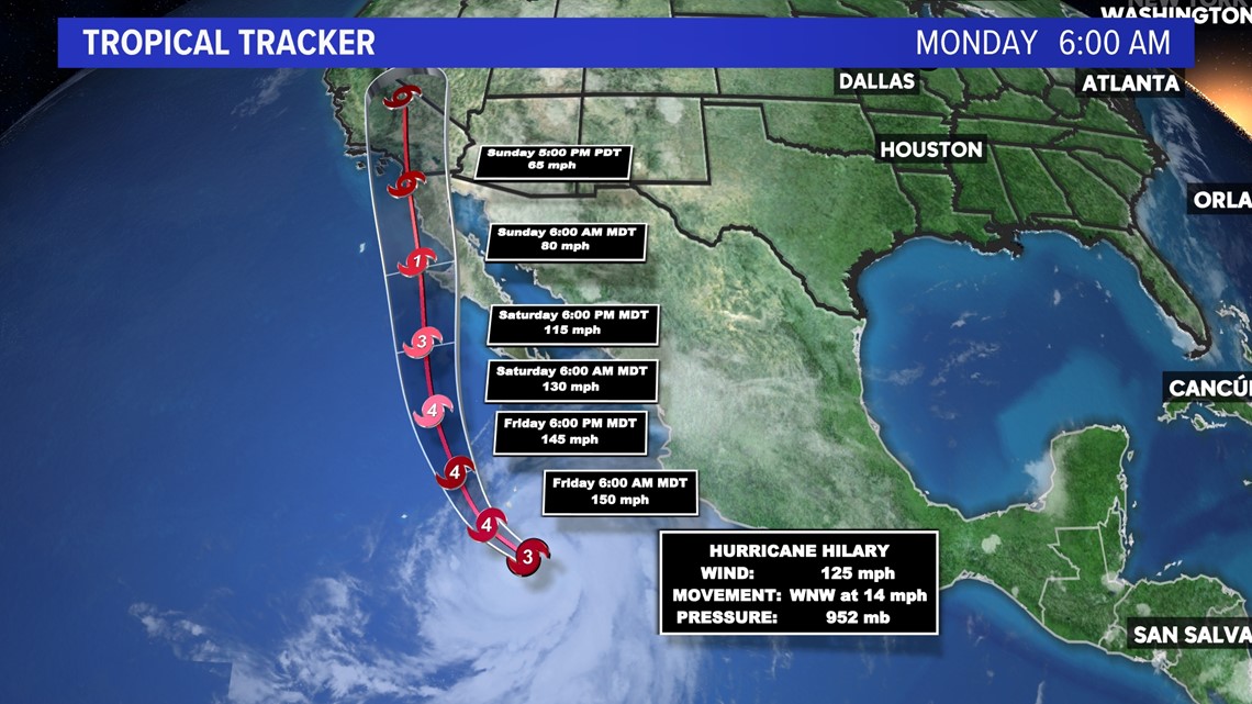
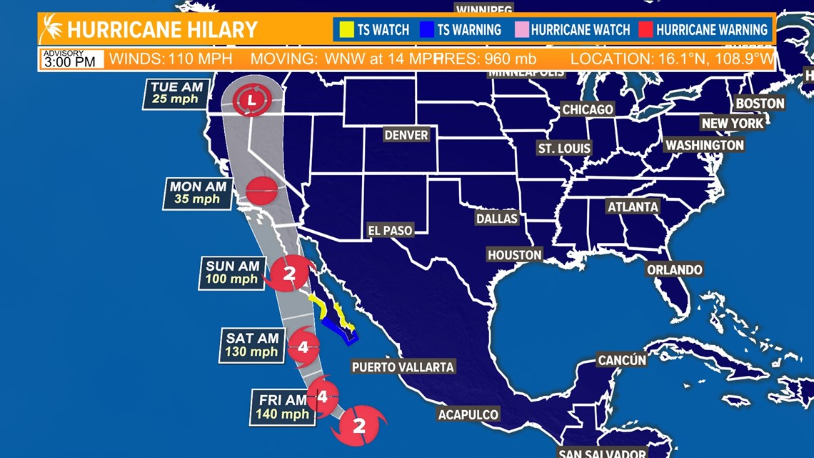
Hurricane Hilary became a Category 4 hurricane early Friday morning and remained that strength throughout the day. As of 9:00 pm Friday, central pressure was 948 millibars. Sustained winds are 130 mph. It's movement is NW 13 mph.

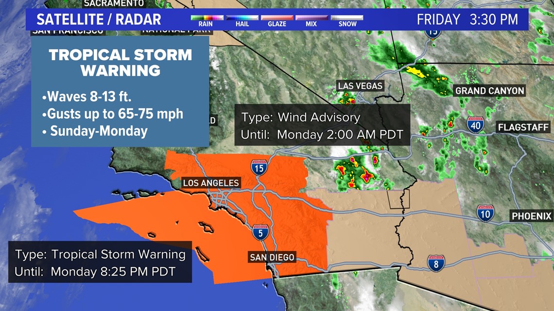
The first ever Tropical Storm Watch was issued for southern California. That has since been upgraded to a Tropical Storm Warning, spanning the California-Mexico border to as north as Palmdale. Wind speeds are expected to be near 35-45 mph with gusts as high as 70 mph.

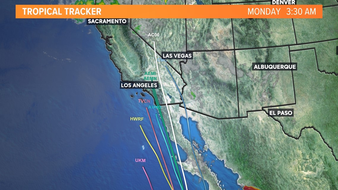
The track of Hurricane Hilary has the system remain a hurricane at landfall in Baja California, then becoming a Tropical Storm as it moves across the border into San Diego. Landfall into California is expected to be around 6pm Sunday.
Tracking Hurricane Hilary | 10 p.m. Update
Hurricane Hilary quickly intensifies through Thursday night. Latest models show Hilary with a minimal central pressure of 953 millibars. Sustained winds are now 125 mph, just 4 mph away from becoming a Category 4 Hurricane. It's current movement is W NW 14 mph.
While computer models keep shifting between a Category 1 or 2 hurricane at landfall south of Tijuana, it's movement into San Diego could either remain at hurricane status or become a Tropical Storm.

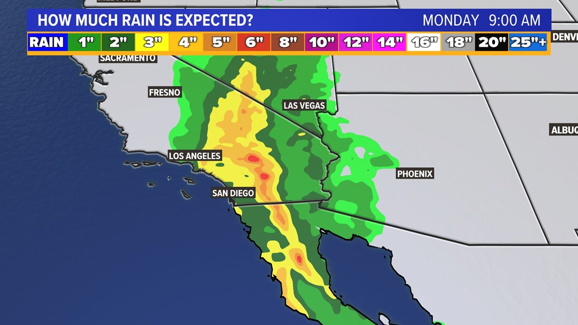
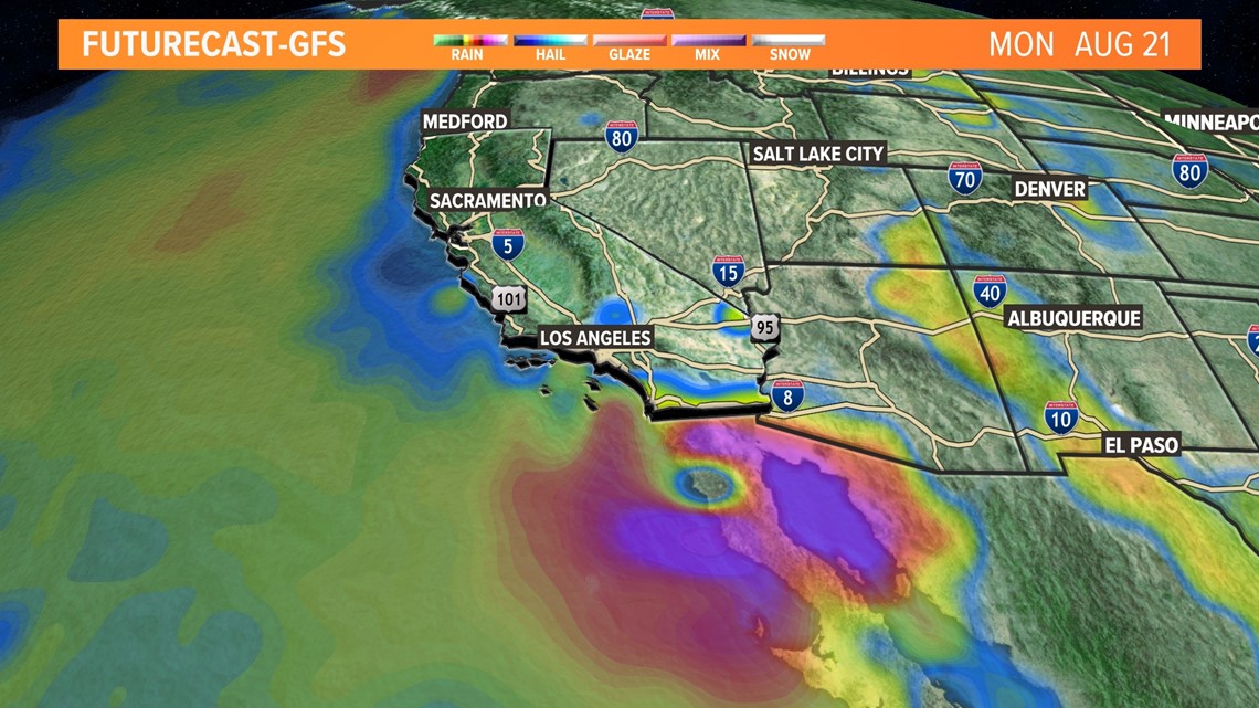
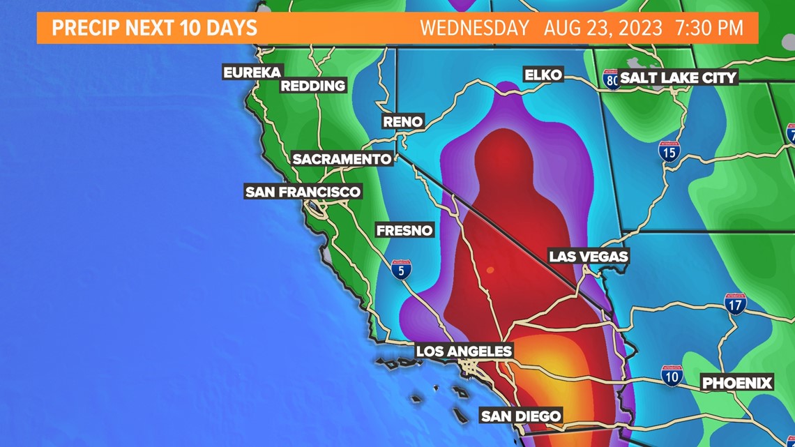
Regardless of its strength, heavy rain and flash flooding is a huge concern. Models are showing as much as 2-6 inches of rain possible from San Diego, up through Orange County/Los Angeles, before shifting to the northeast Monday morning. Areas of southwest Arizona are expecting rain, along with a majority of the state of Nevada receiving copious amounts of rainfall.

Tracking Hurricane Hilary as it nears California | 3 p.m.
Hurricane Hilary is now on the cusp of becoming a major hurricane off the coast of Mexico.
The latest update from the National Hurricane Center shows that the hurricane has a central pressure of 960 millibars and maximum sustained winds of 110 miles per hour. This is just outside the threshold of 111 miles per hour for a Category 3, or Major, Hurricane.
It is expected to continue to strengthen by another 25-30 miles per hour in the next 24 hours and is likely to be a Category 4 hurricane by Friday morning. Strengthening will continue for the next 24-48 hours before it eventually encounters cooler sea surface temperatures as it tracks along the coast of Baja California.
The potential impacts remain the same as previously mentioned but the small wobbles in the hurricane's path from east to west in the coming days will alter precipitation amounts and wind gusts across the state. Impacts here in Northern California will be elevated humidity, increased cloud cover and possibly some light rain in the valley while the Sierra will pick up higher totals.

Hurricane Hilary headed to California - 11 a.m.
Tropical Storm Hilary strengthened into a hurricane early Thursday. For now, it's looking pretty likely that Hurricane Hilary will impact Southern California and the Southwest as it continues to move north over the weekend.
As of Thursday morning, Hurricane Hilary has winds close to 80mph at the core. This is a Category 2 hurricane but strengthening is expected up to a Category 3-4 before weakening as it moves into cooler water off the coast of central and northern Baja.
The water off the coast of Mexico is warmer than normal due to a brewing El Niño and systems that typically form off the coast only to dwindle moving westward have better odds to hold on to intensity with the warmer water.
Hilary is making a rare steep move directly north of the coast of Baja and most computer models are in great agreement it will continue on this path

Preparations should be made in Southern California and the Southwest for widespread rain, wind and coastal impacts like large waves, and erosion along with surge.
The forecast path and intensity will change over the coming days but as of Thursday morning, the storm maintains tropical storm strength with the center making landfall between San Diego and Santa Barbara. Gusts up to 80mph can occur with trees down, roads blocked and power outages all possible.

Heavy rain will intensify in higher elevations with 5-7" totals possible and more in localized areas. Lower rain amounts in deserts still carry flash flooding risks that do not stop at the border. Numerous bridges and arroyos in Baja are at risk of flooding with the increased heavy rain and travel will be impacted.

Average rain in August for Southern California is very low so this will likely break all sorts of records.
While this storm is extremely rare, something similar has happened in the past. Historic records indicate a storm reaching tropical storm criteria made landfall near Long Beach in September 1939. This is in an era before satellites and the current naming protocol. Many areas flooded and many lives were lost. Up to 45 people were killed in flooding alone.
Modern forecasting is giving several days of warning but with 23 million people living in Southern California, it is likely there will be many impacts related to heavy rain, flooding, strong winds and coastal waves, surge and erosion.
Over the weekend the forecast will change details but the overall path and tropical weather is something people should prepare for and monitor.
The current forecast has the core of the storm making landfall very early Monday morning.
Watch more on ABC10


