SACRAMENTO, Calif. — The first full week of January brought a lot of rain to Northern California with some snowy conditions in the Sierra. Valley rain totals around the region since the New Year are widely in the 1-2" range with some locally higher amounts. Foothill and Sierra locations saw greater rainfall amounts.
- Placerville: 15.42"
- Woodland: 6.06"
- Arnold: 5.34"
- Wheatland: 2.93"
- Vacaville: 2.92"
- Sacramento International Airport: 2.52"
- Sacramento Downtown: 2.31"
- Orangevale: 2.24"
- Elk Grove: 2.16"
- Sacramento Executive: 2.13"
- Davis: 1.52"
- Stockton: 1.25"
- Modesto: 1.18"
In terms of snowfall, most Tahoe locations saw around a foot or less with Palisades Tahoe having received 6", Boreal 7", and Sugar Bowl 8". Heavenly and Kirkwood each made into double digits, with one-foot and 14", respectively.
Central Sierra locations along Highway 4 all recorded amounts around 18".
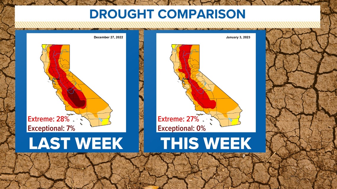
All of the rain and snow made a nice dent in our statewide drought, completely eliminating the highest level, or "exceptional," drought in the San Joaquin Valley. There's still a long way to go and a lot more rain in the forecast.


With more rain coming this weekend and a major atmospheric river-fed storm on Monday, I expect we will see more improvements to the drought monitor next week. However, too much of a good thing is still too much of a good thing.
Without breaks between these storms, rivers and creeks don't have time to move the water and return to pre-storm levels. This means the risk of flooding will remain high through this coming week.
WATCH MORE ON ABC10: Was the bomb cyclone a drought buster?


