

SACRAMENTO, Calif. — See our updated timeline for Monday HERE.
---------------------
Lots of weather changes this week as two systems bring a variety of changes. The combined theme is for lower temperatures that are quite a bit below normal and periods of light rain and showers.
Update: 830am Monday

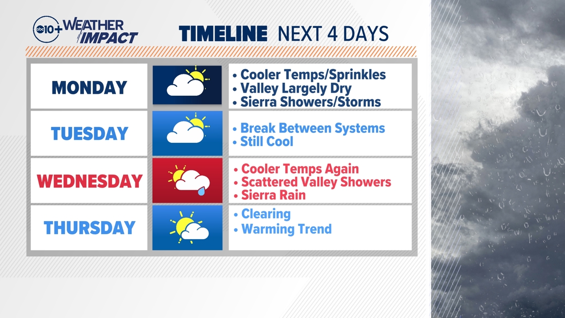
MONDAY
The actual center of the first system arrives on Monday, meaning even cooler temperatures across the region. The valley will likely be in the low to middle 70s on Monday, which will be 15 to 20 degrees below average for the time of year.
We'll also have a chance of showers.
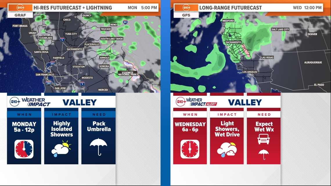
Valley rain chances on Monday are expected to be highly scattered, with the best chances during the morning hours. Not much is expected and most valley locations likely stary dry. A sprinkle is not out of the question but totals will be very low. It's not a bad idea to plan to bring an umbrella with you just in case!
The best opportunity for rain will be in the high country, with shower chances pretty much all day long in the foothills and Sierra.
Things will feel much cooler. You might even want a jacket if you're out early or late. And yes, we could see some light valley showers. But nothing about Monday's forecast feels truly disruptive outside of the high country.

One of the things we'll be watching for is showers and thunderstorms in the foothills, particularly in Butte and Tehama counties because this could lead to debris flows in the Park Fire burn scar.
We could also see some snow in the Sierra. Snow levels in the Central Sierra are looking to drop as low as 7,200 feet, which would put just a dusting of snow on the high passes of I-80 and Highway 50.
There is a Winter Weather Advisory for the Southern Sierra and Yosemite high country from Sunday night to Monday night, as a few inches of snow are expected above 8,000 feet. This is the first Winter Weather Advisory issued by the NWS office in Hanford since early May. Snow for Tioga pass is possible.
WEATHER RESOURCES:
► FORECAST DETAILS | Check out our hourly forecast and radar pages
► GET WEATHER ALERTS TO YOUR PHONE | Download the free ABC10 mobile app
► GO DEEPER | Stream in-depth weather forecasts with the free ABC10+ streaming app
► WEATHER IN YOUR EMAIL | Sign up for our daily newsletter
► MEET THE WEATHER TEAM | Chief Meteorologist Monica Woods, Carley Gomez, Brenden Mincheff, Rob Carlmark
TUESDAY
Tuesday is a bit of a break in the weather. The first system will be exiting the region so we'll have clearing skies and warmer temps in the upper 70s and low 80s. Still well below average, but not as cool as Monday.
WEDNESDAY
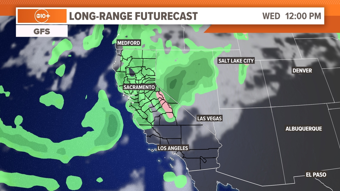
As the second system arrives midweek, afternoon temperatures again cool down into in the 70s. Wednesday also has a better and more widespread chance for showers.
At this point rain will start in the Sierra with widespread showers and snow to about 8,000 ft. This system will not be as cold and will result in mostly rain for the Sierra. We should get at least 0.25-0.50" of rain up high.
For valley locations clouds will move in early and a random shower is possible during the day. The most likely time for steady light rain is in the evening past sunset but this could change. Keep watching the forecast.

THURSDAY
The second storm system will be exiting the region on Thursday, bringing an end to the cooler and unsettled weather pattern.
A brief period of some north winds down the valley is possible Thursday morning through the early afternoon as the system leaves the area.
Temperatures will undergo a slow warming trend beginning with an afternoon in the low to mid-80s on Thursday. By the weekend, we're back in the 90s.
Sunday is the first official day of Fall and temperatures will be near 92. Monday it's back to the mid 90s. Enjoy the changes in the weather this week.
WATCH MORE: What does La Nina mean for California?


